You are here: Home > Network List > N4 - Central and EAstern US Network Stations List
> Station Q51A Peebles, OH, USA > Earthquake Result Viewer
Q51A Peebles, OH, USA - Earthquake Result Viewer
| Earthquake location: |
Near Coast Of Peru |
| Earthquake latitude/longitude: |
-14.5/-76.2 |
| Earthquake time(UTC): |
2022/10/29 (302) 00:09:46 GMT |
| Earthquake Depth: |
7.7 km |
| Earthquake Magnitude: |
5.8 mww |
| Earthquake Catalog/Contributor: |
NEIC PDE/us |
|
| Network: |
N4 Central and EAstern US Network |
| Station: |
Q51A Peebles, OH, USA |
| Lat/Lon: |
39.03 N/83.35 W |
| Elevation: |
362 m |
|
| Distance: |
53.7 deg |
| Az: |
353.089 deg |
| Baz: |
171.397 deg |
| Ray Param: |
0.06594151 |
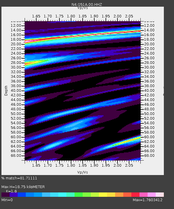
| Estimated Moho Depth: |
18.75 km |
| Estimated Crust Vp/Vs: |
1.60 |
| Assumed Crust Vp: |
6.232 km/s |
| Estimated Crust Vs: |
3.895 km/s |
| Estimated Crust Poisson's Ratio: |
0.18 |
|
| Radial Match: |
81.71111 % |
| Radial Bump: |
400 |
| Transverse Match: |
66.37346 % |
| Transverse Bump: |
396 |
| SOD ConfigId: |
29669891 |
| Insert Time: |
2022-11-12 01:25:37.651 +0000 |
| GWidth: |
2.5 |
| Max Bumps: |
400 |
| Tol: |
0.001 |
|

Signal To Noise
| Channel | StoN | STA | LTA |
| N4:Q51A:00:HHZ:20221029T00:18:38.270015Z | 2.0422773 | 7.9715267E-7 | 3.9032537E-7 |
| N4:Q51A:00:HH1:20221029T00:18:38.270015Z | 1.4905931 | 4.6635586E-7 | 3.1286598E-7 |
| N4:Q51A:00:HH2:20221029T00:18:38.270015Z | 0.87490654 | 3.6961683E-7 | 4.2246435E-7 |
| Arrivals |
| Ps | 1.9 SECOND |
| PpPs | 7.4 SECOND |
| PsPs/PpSs | 9.3 SECOND |


