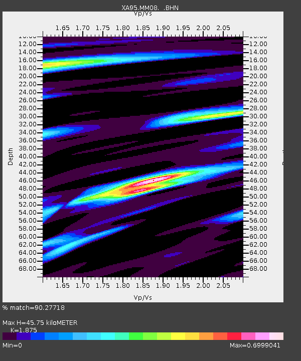
MM08 Slippery Rock , Pennsylvania - Earthquake Result Viewer
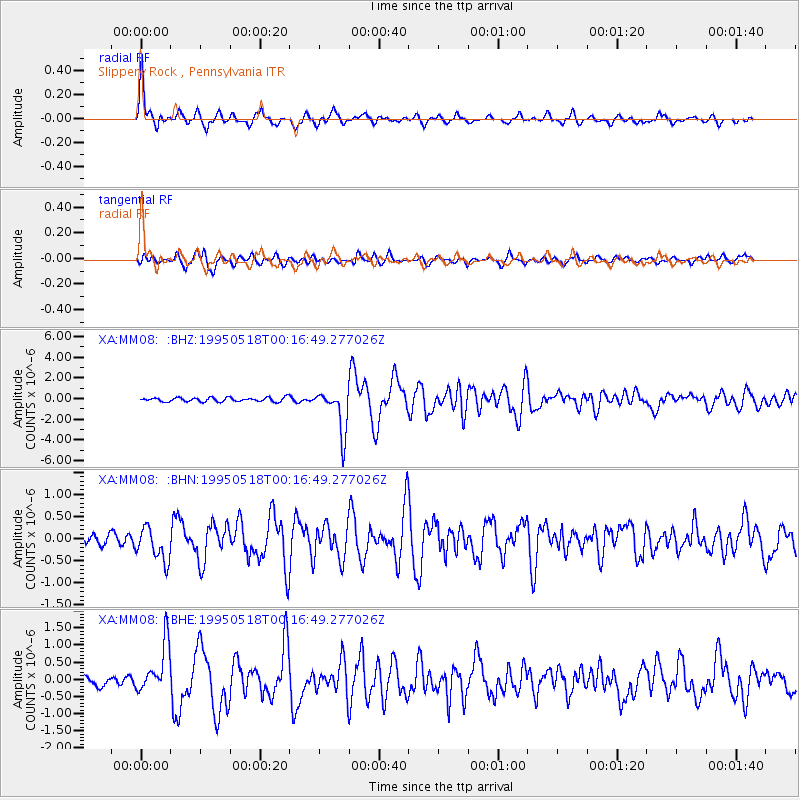
Earthquake location: Central Mid-Atlantic Ridge
Earthquake latitude/longitude: -0.9/-22.0
Earthquake time(UTC): 1995/05/18 (138) 00:06:26 GMT
Earthquake Depth: 10 km
Earthquake Magnitude: 6.2 MB, 6.1 MS, 6.8 UNKNOWN, 6.7 MW
Earthquake Catalog/Contributor: WHDF/NEIC
Network: XA Missouri to Massachusetts Transect
Station: MM08 Slippery Rock , Pennsylvania
Lat/Lon: 41.11 N/80.07 W
Elevation: 381 m
Distance: 67.1 deg
Az: 315.883 deg
Baz: 112.91 deg
Ray Param: 0.057157718
Estimated Moho Depth: 45.75 km
Estimated Crust Vp/Vs: 1.88
Assumed Crust Vp: 6.483 km/s
Estimated Crust Vs: 3.457 km/s
Estimated Crust Poisson's Ratio: 0.30
Radial Match: 90.27718 %
Radial Bump: 400
Transverse Match: 78.588264 %
Transverse Bump: 400
SOD ConfigId: 6273
Insert Time: 2010-02-26 17:49:02.836 +0000
GWidth: 2.5
Max Bumps: 400
Tol: 0.001

Signal To Noise

ChannelStoNSTALTA
XA:MM08: :BHN:19950518T00:16:49.277026Z3.1124433.837761E-71.2330382E-7
XA:MM08: :BHE:19950518T00:16:49.277026Z5.55615857.216454E-71.2988207E-7
XA:MM08: :BHZ:19950518T00:16:49.277026Z10.9265662.1202923E-61.9404926E-7
Arrivals
Ps6.4 SECOND
PpPs20 SECOND
PsPs/PpSs26 SECOND