You are here: Home > Network List > XA95 - Missouri to Massachusetts Transect Stations List
> Station MM08 Slippery Rock , Pennsylvania > Earthquake Result Viewer
MM08 Slippery Rock , Pennsylvania - Earthquake Result Viewer
| Earthquake location: |
Kuril Islands |
| Earthquake latitude/longitude: |
44.1/148.1 |
| Earthquake time(UTC): |
1995/04/28 (118) 16:30:00 GMT |
| Earthquake Depth: |
29 km |
| Earthquake Magnitude: |
6.6 MB, 6.9 MS, 7.0 UNKNOWN, 6.8 MW |
| Earthquake Catalog/Contributor: |
WHDF/NEIC |
|
| Network: |
XA Missouri to Massachusetts Transect |
| Station: |
MM08 Slippery Rock , Pennsylvania |
| Lat/Lon: |
41.11 N/80.07 W |
| Elevation: |
381 m |
|
| Distance: |
84.8 deg |
| Az: |
34.398 deg |
| Baz: |
327.383 deg |
| Ray Param: |
0.045170423 |
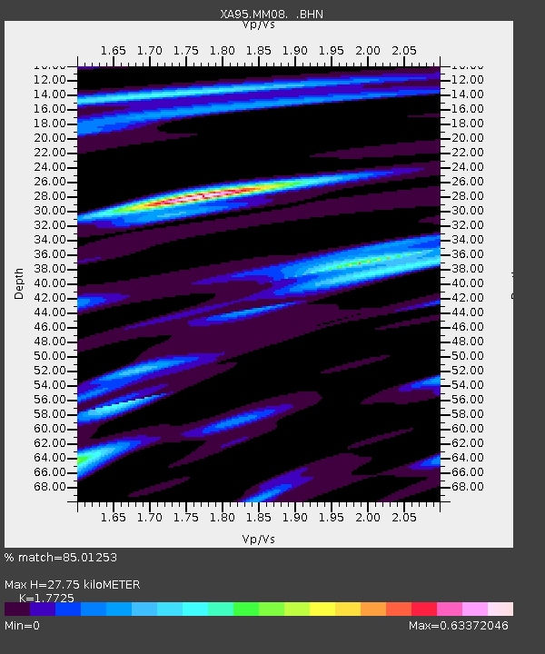
| Estimated Moho Depth: |
27.75 km |
| Estimated Crust Vp/Vs: |
1.77 |
| Assumed Crust Vp: |
6.483 km/s |
| Estimated Crust Vs: |
3.657 km/s |
| Estimated Crust Poisson's Ratio: |
0.27 |
|
| Radial Match: |
85.01253 % |
| Radial Bump: |
363 |
| Transverse Match: |
82.67164 % |
| Transverse Bump: |
387 |
| SOD ConfigId: |
6273 |
| Insert Time: |
2010-02-26 17:49:04.350 +0000 |
| GWidth: |
2.5 |
| Max Bumps: |
400 |
| Tol: |
0.001 |
|

Signal To Noise
| Channel | StoN | STA | LTA |
| XA:MM08: :BHN:19950428T16:42:01.140002Z | 1.9423451 | 8.7793836E-7 | 4.5199917E-7 |
| XA:MM08: :BHE:19950428T16:42:01.140002Z | 1.9141518 | 8.7296485E-7 | 4.560583E-7 |
| XA:MM08: :BHZ:19950428T16:42:01.140002Z | 5.860627 | 3.151501E-6 | 5.377413E-7 |
| Arrivals |
| Ps | 3.4 SECOND |
| PpPs | 12 SECOND |
| PsPs/PpSs | 15 SECOND |


