You are here: Home > Network List > G - GEOSCOPE Stations List
> Station MPG Montagne des Peres, French Guyana > Earthquake Result Viewer
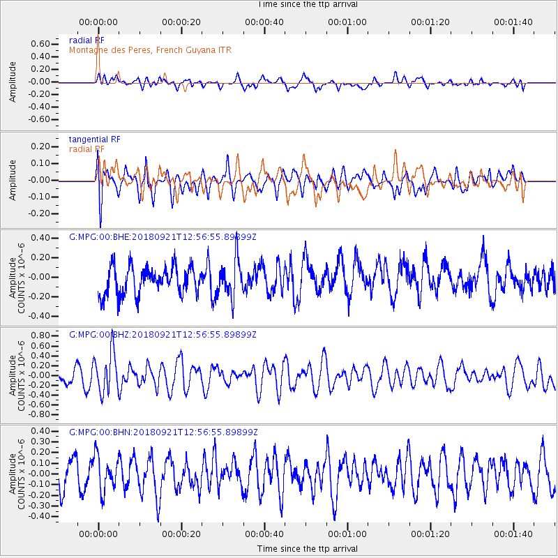
MPG Montagne des Peres, French Guyana - Earthquake Result Viewer
*The percent match for this event was below the threshold and hence no stack was calculated.
| Earthquake location: |
Galapagos Islands Region |
| Earthquake latitude/longitude: |
2.4/-95.5 |
| Earthquake time(UTC): |
2018/09/21 (264) 12:49:28 GMT |
| Earthquake Depth: |
10 km |
| Earthquake Magnitude: |
5.7 Mww |
| Earthquake Catalog/Contributor: |
NEIC PDE/us |
|
| Network: |
G GEOSCOPE |
| Station: |
MPG Montagne des Peres, French Guyana |
| Lat/Lon: |
5.11 N/52.64 W |
| Elevation: |
147 m |
|
| Distance: |
42.8 deg |
| Az: |
85.12 deg |
| Baz: |
268.05 deg |
| Ray Param: |
$rayparam |
*The percent match for this event was below the threshold and hence was not used in the summary stack. |
|
| Radial Match: |
42.152966 % |
| Radial Bump: |
400 |
| Transverse Match: |
61.581223 % |
| Transverse Bump: |
400 |
| SOD ConfigId: |
2963291 |
| Insert Time: |
2018-10-05 12:57:06.970 +0000 |
| GWidth: |
2.5 |
| Max Bumps: |
400 |
| Tol: |
0.001 |
|
Signal To Noise
| Channel | StoN | STA | LTA |
| G:MPG:00:BHZ:20180921T12:56:55.89899Z | 2.5353644 | 4.1327053E-7 | 1.6300241E-7 |
| G:MPG:00:BHN:20180921T12:56:55.89899Z | 1.0451411 | 1.6419989E-7 | 1.5710786E-7 |
| G:MPG:00:BHE:20180921T12:56:55.89899Z | 1.3978256 | 1.9715038E-7 | 1.4104076E-7 |
| Arrivals |
| Ps | |
| PpPs | |
| PsPs/PpSs | |


