You are here: Home > Network List > IU - Global Seismograph Network (GSN - IRIS/USGS) Stations List
> Station RSSD Black Hills, South Dakota, USA > Earthquake Result Viewer
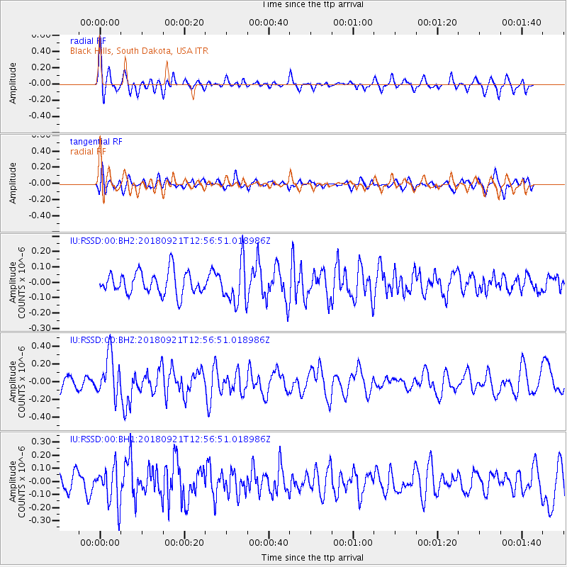
RSSD Black Hills, South Dakota, USA - Earthquake Result Viewer
*The percent match for this event was below the threshold and hence no stack was calculated.
| Earthquake location: |
Galapagos Islands Region |
| Earthquake latitude/longitude: |
2.4/-95.5 |
| Earthquake time(UTC): |
2018/09/21 (264) 12:49:28 GMT |
| Earthquake Depth: |
10 km |
| Earthquake Magnitude: |
5.7 Mww |
| Earthquake Catalog/Contributor: |
NEIC PDE/us |
|
| Network: |
IU Global Seismograph Network (GSN - IRIS/USGS) |
| Station: |
RSSD Black Hills, South Dakota, USA |
| Lat/Lon: |
44.12 N/104.04 W |
| Elevation: |
2090 m |
|
| Distance: |
42.2 deg |
| Az: |
350.823 deg |
| Baz: |
167.217 deg |
| Ray Param: |
$rayparam |
*The percent match for this event was below the threshold and hence was not used in the summary stack. |
|
| Radial Match: |
68.51761 % |
| Radial Bump: |
400 |
| Transverse Match: |
55.746914 % |
| Transverse Bump: |
400 |
| SOD ConfigId: |
2963291 |
| Insert Time: |
2018-10-05 12:58:20.546 +0000 |
| GWidth: |
2.5 |
| Max Bumps: |
400 |
| Tol: |
0.001 |
|
Signal To Noise
| Channel | StoN | STA | LTA |
| IU:RSSD:00:BHZ:20180921T12:56:51.018986Z | 3.1697602 | 2.3994372E-7 | 7.569775E-8 |
| IU:RSSD:00:BH1:20180921T12:56:51.018986Z | 2.780757 | 1.4823149E-7 | 5.330617E-8 |
| IU:RSSD:00:BH2:20180921T12:56:51.018986Z | 1.9315181 | 1.3816346E-7 | 7.153102E-8 |
| Arrivals |
| Ps | |
| PpPs | |
| PsPs/PpSs | |


