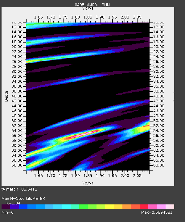
MM08 Slippery Rock , Pennsylvania - Earthquake Result Viewer

Earthquake location: Northern Mid-Atlantic Ridge
Earthquake latitude/longitude: 33.8/-38.6
Earthquake time(UTC): 1995/04/17 (107) 07:14:35 GMT
Earthquake Depth: 10 km
Earthquake Magnitude: 5.8 MB, 5.8 MS, 5.9 UNKNOWN, 6.1 MW
Earthquake Catalog/Contributor: WHDF/NEIC
Network: XA Missouri to Massachusetts Transect
Station: MM08 Slippery Rock , Pennsylvania
Lat/Lon: 41.11 N/80.07 W
Elevation: 381 m
Distance: 33.5 deg
Az: 294.894 deg
Baz: 89.027 deg
Ray Param: 0.07818836
Estimated Moho Depth: 55.0 km
Estimated Crust Vp/Vs: 1.84
Assumed Crust Vp: 6.483 km/s
Estimated Crust Vs: 3.523 km/s
Estimated Crust Poisson's Ratio: 0.29
Radial Match: 85.6412 %
Radial Bump: 362
Transverse Match: 64.94605 %
Transverse Bump: 400
SOD ConfigId: 6273
Insert Time: 2010-02-26 17:49:10.560 +0000
GWidth: 2.5
Max Bumps: 400
Tol: 0.001

Signal To Noise

ChannelStoNSTALTA
XA:MM08: :BHN:19950417T07:20:43.788989Z1.06524041.4790946E-71.3885078E-7
XA:MM08: :BHE:19950417T07:20:43.788989Z2.93733123.661365E-71.2464938E-7
XA:MM08: :BHZ:19950417T07:20:43.788989Z3.25268487.888729E-72.4252978E-7
Arrivals
Ps7.7 SECOND
PpPs22 SECOND
PsPs/PpSs30 SECOND