You are here: Home > Network List > NM - Cooperative New Madrid Seismic Network Stations List
> Station FFIL Fairfield, IL > Earthquake Result Viewer
FFIL Fairfield, IL - Earthquake Result Viewer
| Earthquake location: |
Galapagos Islands Region |
| Earthquake latitude/longitude: |
2.4/-95.5 |
| Earthquake time(UTC): |
2018/09/21 (264) 12:49:28 GMT |
| Earthquake Depth: |
10 km |
| Earthquake Magnitude: |
5.7 Mww |
| Earthquake Catalog/Contributor: |
NEIC PDE/us |
|
| Network: |
NM Cooperative New Madrid Seismic Network |
| Station: |
FFIL Fairfield, IL |
| Lat/Lon: |
38.38 N/88.39 W |
| Elevation: |
446 m |
|
| Distance: |
36.4 deg |
| Az: |
9.412 deg |
| Baz: |
191.998 deg |
| Ray Param: |
0.07671299 |
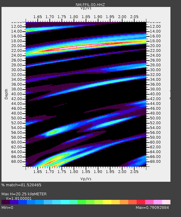
| Estimated Moho Depth: |
20.25 km |
| Estimated Crust Vp/Vs: |
1.81 |
| Assumed Crust Vp: |
6.444 km/s |
| Estimated Crust Vs: |
3.56 km/s |
| Estimated Crust Poisson's Ratio: |
0.28 |
|
| Radial Match: |
81.528465 % |
| Radial Bump: |
393 |
| Transverse Match: |
55.54144 % |
| Transverse Bump: |
400 |
| SOD ConfigId: |
2963291 |
| Insert Time: |
2018-10-05 12:59:12.255 +0000 |
| GWidth: |
2.5 |
| Max Bumps: |
400 |
| Tol: |
0.001 |
|

Signal To Noise
| Channel | StoN | STA | LTA |
| NM:FFIL:00:HHZ:20180921T12:56:02.329014Z | 4.071411 | 5.455316E-7 | 1.3399078E-7 |
| NM:FFIL:00:HHN:20180921T12:56:02.329014Z | 2.8977087 | 3.4605915E-7 | 1.1942511E-7 |
| NM:FFIL:00:HHE:20180921T12:56:02.329014Z | 0.8253493 | 1.2000706E-7 | 1.4540154E-7 |
| Arrivals |
| Ps | 2.7 SECOND |
| PpPs | 8.2 SECOND |
| PsPs/PpSs | 11 SECOND |


