You are here: Home > Network List > UW - Pacific Northwest Regional Seismic Network Stations List
> Station UMAT Pilot Rock, OR, USA > Earthquake Result Viewer
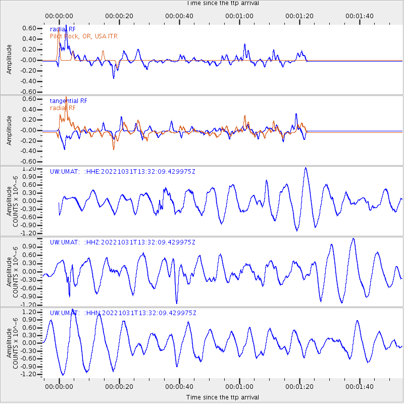
UMAT Pilot Rock, OR, USA - Earthquake Result Viewer
*The percent match for this event was below the threshold and hence no stack was calculated.
| Earthquake location: |
Peru-Ecuador Border Region |
| Earthquake latitude/longitude: |
-2.4/-76.2 |
| Earthquake time(UTC): |
2022/10/31 (304) 13:22:43 GMT |
| Earthquake Depth: |
148 km |
| Earthquake Magnitude: |
5.6 mww |
| Earthquake Catalog/Contributor: |
NEIC PDE/us |
|
| Network: |
UW Pacific Northwest Regional Seismic Network |
| Station: |
UMAT Pilot Rock, OR, USA |
| Lat/Lon: |
45.29 N/118.96 W |
| Elevation: |
1318 m |
|
| Distance: |
60.8 deg |
| Az: |
326.7 deg |
| Baz: |
129.006 deg |
| Ray Param: |
$rayparam |
*The percent match for this event was below the threshold and hence was not used in the summary stack. |
|
| Radial Match: |
67.11591 % |
| Radial Bump: |
374 |
| Transverse Match: |
58.99802 % |
| Transverse Bump: |
259 |
| SOD ConfigId: |
29669891 |
| Insert Time: |
2022-11-14 14:50:49.631 +0000 |
| GWidth: |
2.5 |
| Max Bumps: |
400 |
| Tol: |
0.001 |
|
Signal To Noise
| Channel | StoN | STA | LTA |
| UW:UMAT: :HHZ:20221031T13:32:09.429975Z | 1.1857202 | 3.469036E-7 | 2.9256785E-7 |
| UW:UMAT: :HHN:20221031T13:32:09.429975Z | 2.8778892 | 8.665697E-7 | 3.0111295E-7 |
| UW:UMAT: :HHE:20221031T13:32:09.429975Z | 1.3202457 | 2.7763454E-7 | 2.1029005E-7 |
| Arrivals |
| Ps | |
| PpPs | |
| PsPs/PpSs | |


