You are here: Home > Network List > TA - USArray Transportable Network (new EarthScope stations) Stations List
> Station X20A Quemado, NM, USA > Earthquake Result Viewer
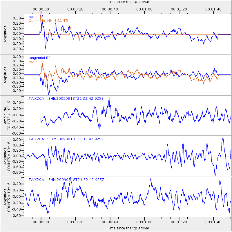
X20A Quemado, NM, USA - Earthquake Result Viewer
*The percent match for this event was below the threshold and hence no stack was calculated.
| Earthquake location: |
South Of Fiji Islands |
| Earthquake latitude/longitude: |
-26.1/-178.4 |
| Earthquake time(UTC): |
2009/08/18 (230) 21:20:47 GMT |
| Earthquake Depth: |
270 km |
| Earthquake Magnitude: |
5.5 MB, 6.3 MW, 6.3 MW |
| Earthquake Catalog/Contributor: |
WHDF/NEIC |
|
| Network: |
TA USArray Transportable Network (new EarthScope stations) |
| Station: |
X20A Quemado, NM, USA |
| Lat/Lon: |
34.54 N/108.50 W |
| Elevation: |
2057 m |
|
| Distance: |
89.5 deg |
| Az: |
50.823 deg |
| Baz: |
237.637 deg |
| Ray Param: |
$rayparam |
*The percent match for this event was below the threshold and hence was not used in the summary stack. |
|
| Radial Match: |
49.17257 % |
| Radial Bump: |
400 |
| Transverse Match: |
50.967056 % |
| Transverse Bump: |
400 |
| SOD ConfigId: |
296778 |
| Insert Time: |
2010-03-30 21:27:22.109 +0000 |
| GWidth: |
2.5 |
| Max Bumps: |
400 |
| Tol: |
0.001 |
|
Signal To Noise
| Channel | StoN | STA | LTA |
| TA:X20A: :BHZ:20090818T21:32:42.925Z | 4.74726 | 2.6789567E-7 | 5.6431638E-8 |
| TA:X20A: :BHN:20090818T21:32:42.925Z | 3.0167792 | 3.3531668E-7 | 1.1115056E-7 |
| TA:X20A: :BHE:20090818T21:32:42.925Z | 1.6961437 | 2.2575854E-7 | 1.3310105E-7 |
| Arrivals |
| Ps | |
| PpPs | |
| PsPs/PpSs | |


