You are here: Home > Network List > XA95 - Missouri to Massachusetts Transect Stations List
> Station MM08 Slippery Rock , Pennsylvania > Earthquake Result Viewer
MM08 Slippery Rock , Pennsylvania - Earthquake Result Viewer

| Earthquake location: |
Near Coast Of Peru |
| Earthquake latitude/longitude: |
-10.5/-78.7 |
| Earthquake time(UTC): |
1995/09/23 (266) 22:31:58 GMT |
| Earthquake Depth: |
73 km |
| Earthquake Magnitude: |
5.9 MB, 6.5 UNKNOWN, 6.4 MW |
| Earthquake Catalog/Contributor: |
WHDF/NEIC |
|
| Network: |
XA Missouri to Massachusetts Transect |
| Station: |
MM08 Slippery Rock , Pennsylvania |
| Lat/Lon: |
41.11 N/80.07 W |
| Elevation: |
381 m |
|
| Distance: |
51.4 deg |
| Az: |
358.674 deg |
| Baz: |
178.274 deg |
| Ray Param: |
0.06722691 |
| Estimated Moho Depth: |
49.75 km |
| Estimated Crust Vp/Vs: |
1.71 |
| Assumed Crust Vp: |
6.483 km/s |
| Estimated Crust Vs: |
3.802 km/s |
| Estimated Crust Poisson's Ratio: |
0.24 |
|
| Radial Match: |
90.20133 % |
| Radial Bump: |
335 |
| Transverse Match: |
62.33779 % |
| Transverse Bump: |
400 |
| SOD ConfigId: |
6273 |
| Insert Time: |
2010-02-26 17:49:19.894 +0000 |
| GWidth: |
2.5 |
| Max Bumps: |
400 |
| Tol: |
0.001 |
|
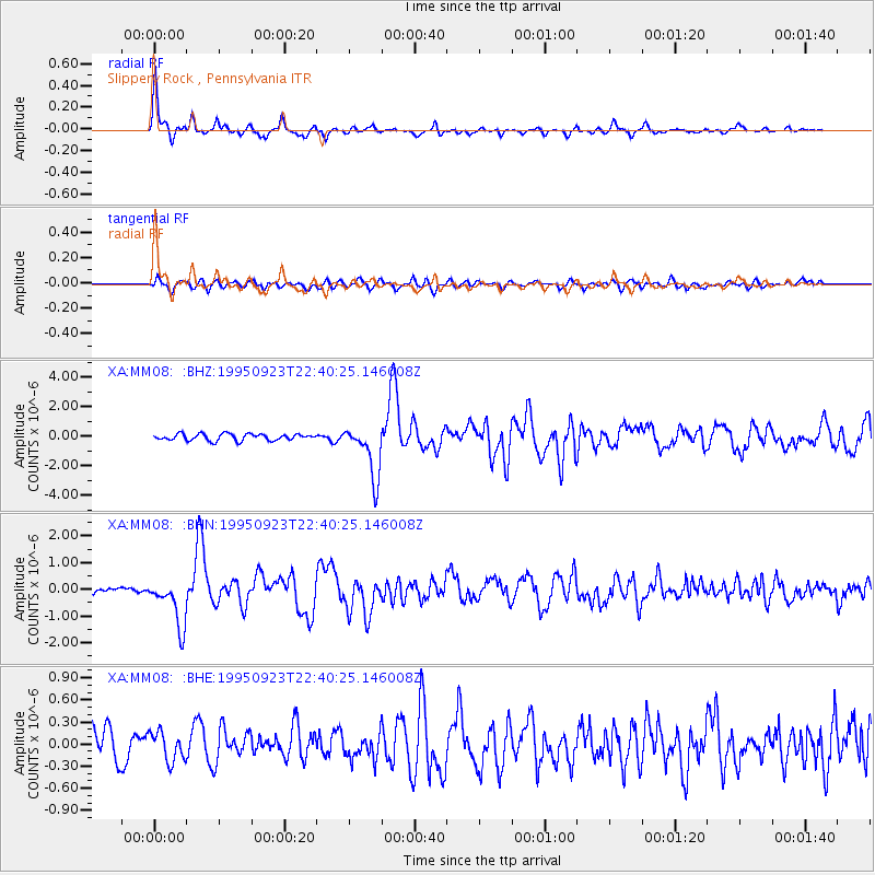
Signal To Noise
| Channel | StoN | STA | LTA |
| XA:MM08: :BHN:19950923T22:40:25.146008Z | 5.3273206 | 8.8663046E-7 | 1.6643084E-7 |
| XA:MM08: :BHE:19950923T22:40:25.146008Z | 0.7194261 | 1.953967E-7 | 2.7160078E-7 |
| XA:MM08: :BHZ:19950923T22:40:25.146008Z | 8.058348 | 1.7928625E-6 | 2.2248513E-7 |
| Arrivals |
| Ps | 5.7 SECOND |
| PpPs | 20 SECOND |
| PsPs/PpSs | 25 SECOND |


