You are here: Home > Network List > XA95 - Missouri to Massachusetts Transect Stations List
> Station MM08 Slippery Rock , Pennsylvania > Earthquake Result Viewer
MM08 Slippery Rock , Pennsylvania - Earthquake Result Viewer
| Earthquake location: |
Turkey |
| Earthquake latitude/longitude: |
38.1/30.2 |
| Earthquake time(UTC): |
1995/10/01 (274) 15:57:16 GMT |
| Earthquake Depth: |
33 km |
| Earthquake Magnitude: |
5.7 MB, 6.1 MS, 6.3 UNKNOWN, 6.0 MW |
| Earthquake Catalog/Contributor: |
WHDF/NEIC |
|
| Network: |
XA Missouri to Massachusetts Transect |
| Station: |
MM08 Slippery Rock , Pennsylvania |
| Lat/Lon: |
41.11 N/80.07 W |
| Elevation: |
381 m |
|
| Distance: |
78.7 deg |
| Az: |
313.696 deg |
| Baz: |
49.016 deg |
| Ray Param: |
0.049427725 |
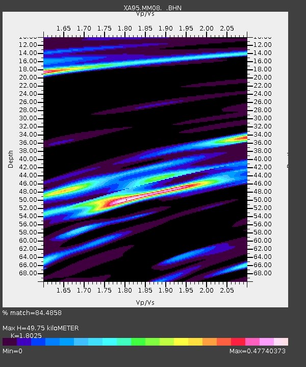
| Estimated Moho Depth: |
49.75 km |
| Estimated Crust Vp/Vs: |
1.80 |
| Assumed Crust Vp: |
6.483 km/s |
| Estimated Crust Vs: |
3.596 km/s |
| Estimated Crust Poisson's Ratio: |
0.28 |
|
| Radial Match: |
84.4858 % |
| Radial Bump: |
314 |
| Transverse Match: |
73.604355 % |
| Transverse Bump: |
392 |
| SOD ConfigId: |
6273 |
| Insert Time: |
2010-02-26 17:49:20.924 +0000 |
| GWidth: |
2.5 |
| Max Bumps: |
400 |
| Tol: |
0.001 |
|
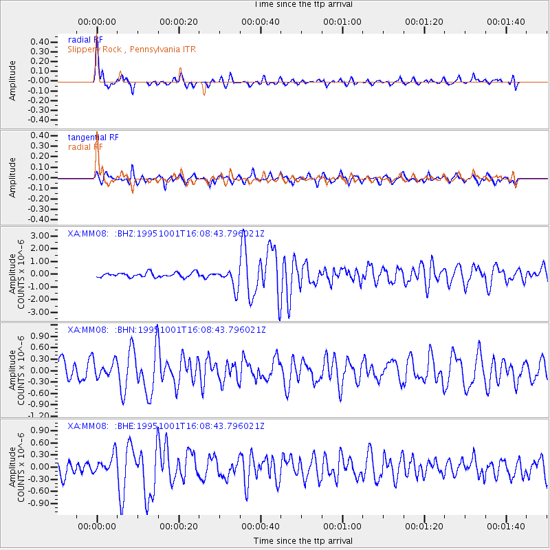
Signal To Noise
| Channel | StoN | STA | LTA |
| XA:MM08: :BHN:19951001T16:08:43.796021Z | 1.0687848 | 2.030789E-7 | 1.9000915E-7 |
| XA:MM08: :BHE:19951001T16:08:43.796021Z | 1.1681347 | 2.3792151E-7 | 2.0367644E-7 |
| XA:MM08: :BHZ:19951001T16:08:43.796021Z | 4.4095697 | 7.7994395E-7 | 1.7687529E-7 |
| Arrivals |
| Ps | 6.3 SECOND |
| PpPs | 21 SECOND |
| PsPs/PpSs | 27 SECOND |


