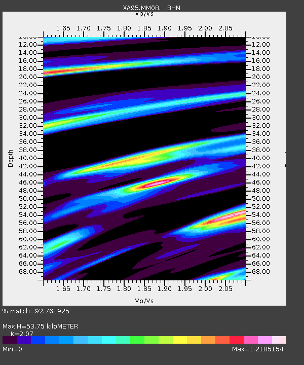
MM08 Slippery Rock , Pennsylvania - Earthquake Result Viewer
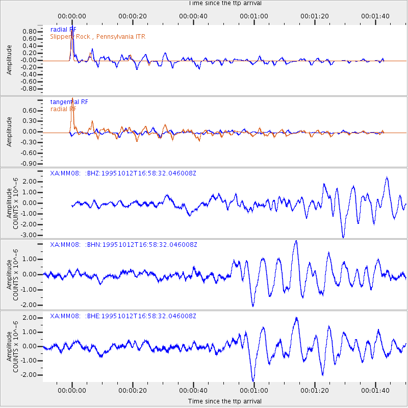
Earthquake location: Near Coast Of Jalisco, Mexico
Earthquake latitude/longitude: 18.8/-104.0
Earthquake time(UTC): 1995/10/12 (285) 16:52:54 GMT
Earthquake Depth: 25 km
Earthquake Magnitude: 5.5 MB, 5.5 MS, 5.2 UNKNOWN, 6.0 MW
Earthquake Catalog/Contributor: WHDF/NEIC
Network: XA Missouri to Massachusetts Transect
Station: MM08 Slippery Rock , Pennsylvania
Lat/Lon: 41.11 N/80.07 W
Elevation: 381 m
Distance: 30.2 deg
Az: 37.562 deg
Baz: 229.828 deg
Ray Param: 0.079374686
Estimated Moho Depth: 53.75 km
Estimated Crust Vp/Vs: 2.07
Assumed Crust Vp: 6.483 km/s
Estimated Crust Vs: 3.132 km/s
Estimated Crust Poisson's Ratio: 0.35
Radial Match: 92.761925 %
Radial Bump: 400
Transverse Match: 71.63538 %
Transverse Bump: 400
SOD ConfigId: 6273
Insert Time: 2010-02-26 17:49:22.041 +0000
GWidth: 2.5
Max Bumps: 400
Tol: 0.001

Signal To Noise

ChannelStoNSTALTA
XA:MM08: :BHN:19951012T16:58:32.046008Z1.96511711.7751805E-79.0334595E-8
XA:MM08: :BHE:19951012T16:58:32.046008Z1.9479592.3650878E-71.2141363E-7
XA:MM08: :BHZ:19951012T16:58:32.046008Z2.63501524.455826E-71.6910057E-7
Arrivals
Ps9.5 SECOND
PpPs24 SECOND
PsPs/PpSs33 SECOND