You are here: Home > Network List > XA95 - Missouri to Massachusetts Transect Stations List
> Station MM08 Slippery Rock , Pennsylvania > Earthquake Result Viewer
MM08 Slippery Rock , Pennsylvania - Earthquake Result Viewer
| Earthquake location: |
Kuril Islands |
| Earthquake latitude/longitude: |
45.3/149.9 |
| Earthquake time(UTC): |
1996/02/07 (038) 21:36:45 GMT |
| Earthquake Depth: |
33 km |
| Earthquake Magnitude: |
6.3 MB, 7.0 MS, 7.2 UNKNOWN, 7.1 MW |
| Earthquake Catalog/Contributor: |
WHDF/NEIC |
|
| Network: |
XA Missouri to Massachusetts Transect |
| Station: |
MM08 Slippery Rock , Pennsylvania |
| Lat/Lon: |
41.11 N/80.07 W |
| Elevation: |
381 m |
|
| Distance: |
83.0 deg |
| Az: |
35.659 deg |
| Baz: |
327.023 deg |
| Ray Param: |
0.04643216 |
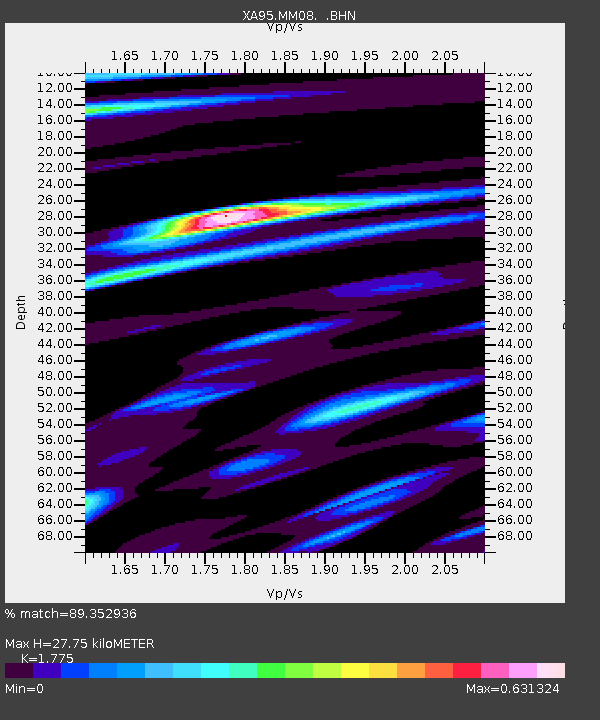
| Estimated Moho Depth: |
27.75 km |
| Estimated Crust Vp/Vs: |
1.77 |
| Assumed Crust Vp: |
6.483 km/s |
| Estimated Crust Vs: |
3.652 km/s |
| Estimated Crust Poisson's Ratio: |
0.27 |
|
| Radial Match: |
89.352936 % |
| Radial Bump: |
400 |
| Transverse Match: |
58.0988 % |
| Transverse Bump: |
365 |
| SOD ConfigId: |
6273 |
| Insert Time: |
2010-02-26 17:49:25.500 +0000 |
| GWidth: |
2.5 |
| Max Bumps: |
400 |
| Tol: |
0.001 |
|
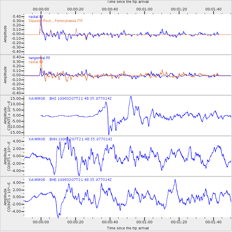
Signal To Noise
| Channel | StoN | STA | LTA |
| XA:MM08: :BHN:19960207T21:48:35.977014Z | 0.8576728 | 4.107623E-7 | 4.7892655E-7 |
| XA:MM08: :BHE:19960207T21:48:35.977014Z | 1.4457841 | 1.2060987E-6 | 8.342177E-7 |
| XA:MM08: :BHZ:19960207T21:48:35.977014Z | 5.7532196 | 2.3729558E-6 | 4.12457E-7 |
| Arrivals |
| Ps | 3.4 SECOND |
| PpPs | 12 SECOND |
| PsPs/PpSs | 15 SECOND |


