You are here: Home > Network List > XA95 - Missouri to Massachusetts Transect Stations List
> Station MM08 Slippery Rock , Pennsylvania > Earthquake Result Viewer
MM08 Slippery Rock , Pennsylvania - Earthquake Result Viewer
| Earthquake location: |
Kuril Islands |
| Earthquake latitude/longitude: |
45.2/148.6 |
| Earthquake time(UTC): |
1996/02/22 (053) 14:59:09 GMT |
| Earthquake Depth: |
133 km |
| Earthquake Magnitude: |
6.2 MB, 6.3 UNKNOWN, 6.3 MW |
| Earthquake Catalog/Contributor: |
WHDF/NEIC |
|
| Network: |
XA Missouri to Massachusetts Transect |
| Station: |
MM08 Slippery Rock , Pennsylvania |
| Lat/Lon: |
41.11 N/80.07 W |
| Elevation: |
381 m |
|
| Distance: |
83.7 deg |
| Az: |
34.786 deg |
| Baz: |
327.743 deg |
| Ray Param: |
0.045719653 |
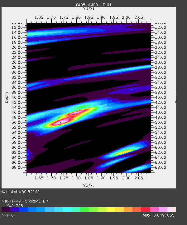
| Estimated Moho Depth: |
49.75 km |
| Estimated Crust Vp/Vs: |
1.74 |
| Assumed Crust Vp: |
6.483 km/s |
| Estimated Crust Vs: |
3.736 km/s |
| Estimated Crust Poisson's Ratio: |
0.25 |
|
| Radial Match: |
80.52181 % |
| Radial Bump: |
400 |
| Transverse Match: |
72.75115 % |
| Transverse Bump: |
389 |
| SOD ConfigId: |
6273 |
| Insert Time: |
2010-02-26 17:49:27.046 +0000 |
| GWidth: |
2.5 |
| Max Bumps: |
400 |
| Tol: |
0.001 |
|

Signal To Noise
| Channel | StoN | STA | LTA |
| XA:MM08: :BHN:19960222T15:10:52.395007Z | 3.4075139 | 5.64053E-7 | 1.6553213E-7 |
| XA:MM08: :BHE:19960222T15:10:52.395007Z | 2.612498 | 4.188746E-7 | 1.603349E-7 |
| XA:MM08: :BHZ:19960222T15:10:52.395007Z | 7.2607937 | 1.8975873E-6 | 2.6134708E-7 |
| Arrivals |
| Ps | 5.8 SECOND |
| PpPs | 20 SECOND |
| PsPs/PpSs | 26 SECOND |


