You are here: Home > Network List > XA95 - Missouri to Massachusetts Transect Stations List
> Station MM08 Slippery Rock , Pennsylvania > Earthquake Result Viewer
MM08 Slippery Rock , Pennsylvania - Earthquake Result Viewer
| Earthquake location: |
Near Coast Of Nicaragua |
| Earthquake latitude/longitude: |
11.7/-86.9 |
| Earthquake time(UTC): |
1996/03/03 (063) 14:55:11 GMT |
| Earthquake Depth: |
33 km |
| Earthquake Magnitude: |
5.7 MB, 6.5 MS, 6.8 UNKNOWN, 6.4 MS |
| Earthquake Catalog/Contributor: |
WHDF/NEIC |
|
| Network: |
XA Missouri to Massachusetts Transect |
| Station: |
MM08 Slippery Rock , Pennsylvania |
| Lat/Lon: |
41.11 N/80.07 W |
| Elevation: |
381 m |
|
| Distance: |
29.9 deg |
| Az: |
10.309 deg |
| Baz: |
193.415 deg |
| Ray Param: |
0.07943213 |
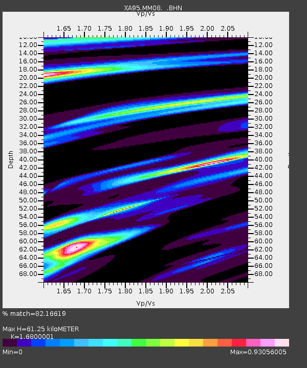
| Estimated Moho Depth: |
61.25 km |
| Estimated Crust Vp/Vs: |
1.68 |
| Assumed Crust Vp: |
6.483 km/s |
| Estimated Crust Vs: |
3.859 km/s |
| Estimated Crust Poisson's Ratio: |
0.23 |
|
| Radial Match: |
82.16619 % |
| Radial Bump: |
337 |
| Transverse Match: |
59.18808 % |
| Transverse Bump: |
400 |
| SOD ConfigId: |
6273 |
| Insert Time: |
2010-02-26 17:49:28.114 +0000 |
| GWidth: |
2.5 |
| Max Bumps: |
400 |
| Tol: |
0.001 |
|
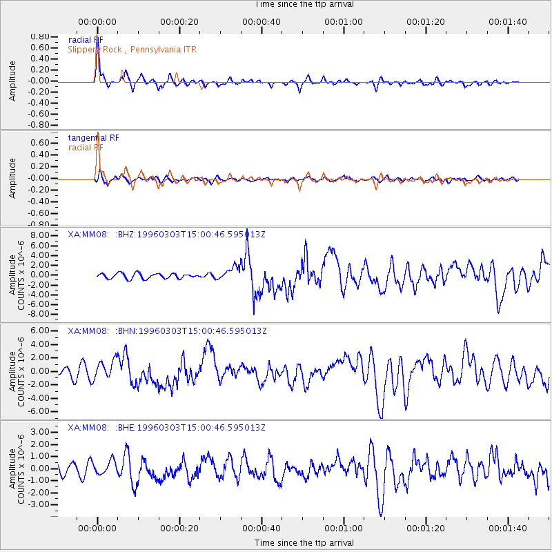
Signal To Noise
| Channel | StoN | STA | LTA |
| XA:MM08: :BHN:19960303T15:00:46.595013Z | 2.8697302 | 1.4650734E-6 | 5.1052655E-7 |
| XA:MM08: :BHE:19960303T15:00:46.595013Z | 1.1103559 | 5.5918855E-7 | 5.03612E-7 |
| XA:MM08: :BHZ:19960303T15:00:46.595013Z | 2.6583018 | 1.3832449E-6 | 5.203491E-7 |
| Arrivals |
| Ps | 7.0 SECOND |
| PpPs | 23 SECOND |
| PsPs/PpSs | 30 SECOND |


