You are here: Home > Network List > N4 - Central and EAstern US Network Stations List
> Station I40B Norwalk, WI, USA > Earthquake Result Viewer
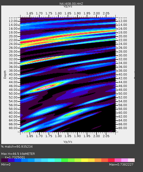
I40B Norwalk, WI, USA - Earthquake Result Viewer
| Earthquake location: |
North Pacific Ocean |
| Earthquake latitude/longitude: |
31.5/-133.4 |
| Earthquake time(UTC): |
2022/11/02 (306) 04:53:13 GMT |
| Earthquake Depth: |
10 km |
| Earthquake Magnitude: |
6.0 mww |
| Earthquake Catalog/Contributor: |
NEIC PDE/us |
|
| Network: |
N4 Central and EAstern US Network |
| Station: |
I40B Norwalk, WI, USA |
| Lat/Lon: |
43.89 N/90.62 W |
| Elevation: |
419 m |
|
| Distance: |
35.6 deg |
| Az: |
57.389 deg |
| Baz: |
264.343 deg |
| Ray Param: |
0.07712643 |
| Estimated Moho Depth: |
46.5 km |
| Estimated Crust Vp/Vs: |
1.73 |
| Assumed Crust Vp: |
6.53 km/s |
| Estimated Crust Vs: |
3.769 km/s |
| Estimated Crust Poisson's Ratio: |
0.25 |
|
| Radial Match: |
90.935234 % |
| Radial Bump: |
355 |
| Transverse Match: |
58.77995 % |
| Transverse Bump: |
400 |
| SOD ConfigId: |
29669891 |
| Insert Time: |
2022-11-16 06:05:53.741 +0000 |
| GWidth: |
2.5 |
| Max Bumps: |
400 |
| Tol: |
0.001 |
|

Signal To Noise
| Channel | StoN | STA | LTA |
| N4:I40B:00:HHZ:20221102T04:59:40.249996Z | 5.151229 | 1.0644533E-6 | 2.0664065E-7 |
| N4:I40B:00:HH1:20221102T04:59:40.249996Z | 1.4351805 | 2.8004288E-7 | 1.9512727E-7 |
| N4:I40B:00:HH2:20221102T04:59:40.249996Z | 5.854209 | 6.974131E-7 | 1.191302E-7 |
| Arrivals |
| Ps | 5.7 SECOND |
| PpPs | 18 SECOND |
| PsPs/PpSs | 24 SECOND |


