You are here: Home > Network List > N4 - Central and EAstern US Network Stations List
> Station M50A Fremont, OH, USA > Earthquake Result Viewer
M50A Fremont, OH, USA - Earthquake Result Viewer
| Earthquake location: |
North Pacific Ocean |
| Earthquake latitude/longitude: |
31.5/-133.4 |
| Earthquake time(UTC): |
2022/11/02 (306) 04:53:13 GMT |
| Earthquake Depth: |
10 km |
| Earthquake Magnitude: |
6.0 mww |
| Earthquake Catalog/Contributor: |
NEIC PDE/us |
|
| Network: |
N4 Central and EAstern US Network |
| Station: |
M50A Fremont, OH, USA |
| Lat/Lon: |
41.40 N/83.04 W |
| Elevation: |
176 m |
|
| Distance: |
41.1 deg |
| Az: |
61.61 deg |
| Baz: |
272.775 deg |
| Ray Param: |
0.07397466 |
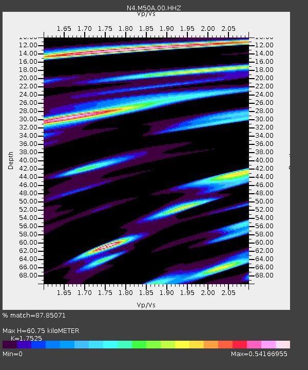
| Estimated Moho Depth: |
60.75 km |
| Estimated Crust Vp/Vs: |
1.75 |
| Assumed Crust Vp: |
6.498 km/s |
| Estimated Crust Vs: |
3.708 km/s |
| Estimated Crust Poisson's Ratio: |
0.26 |
|
| Radial Match: |
87.85071 % |
| Radial Bump: |
400 |
| Transverse Match: |
87.85076 % |
| Transverse Bump: |
400 |
| SOD ConfigId: |
29669891 |
| Insert Time: |
2022-11-16 06:06:12.062 +0000 |
| GWidth: |
2.5 |
| Max Bumps: |
400 |
| Tol: |
0.001 |
|

Signal To Noise
| Channel | StoN | STA | LTA |
| N4:M50A:00:HHZ:20221102T05:00:26.657986Z | 3.013592 | 7.258794E-7 | 2.4086847E-7 |
| $trig.getChannelId() | $trig.getValue() | $trig.getSTA() | $trig.getLTA() |
| N4:M50A:00:HH2:20221102T05:00:26.657986Z | 3.3625743 | 5.986069E-7 | 1.7802041E-7 |
| Arrivals |
| Ps | 7.6 SECOND |
| PpPs | 24 SECOND |
| PsPs/PpSs | 32 SECOND |


