You are here: Home > Network List > NM - Cooperative New Madrid Seismic Network Stations List
> Station HENM Henderson Mound,MO > Earthquake Result Viewer
HENM Henderson Mound,MO - Earthquake Result Viewer
| Earthquake location: |
North Pacific Ocean |
| Earthquake latitude/longitude: |
31.5/-133.4 |
| Earthquake time(UTC): |
2022/11/02 (306) 04:53:13 GMT |
| Earthquake Depth: |
10 km |
| Earthquake Magnitude: |
6.0 mww |
| Earthquake Catalog/Contributor: |
NEIC PDE/us |
|
| Network: |
NM Cooperative New Madrid Seismic Network |
| Station: |
HENM Henderson Mound,MO |
| Lat/Lon: |
36.72 N/89.47 W |
| Elevation: |
88 m |
|
| Distance: |
36.5 deg |
| Az: |
69.594 deg |
| Baz: |
274.966 deg |
| Ray Param: |
0.0767005 |
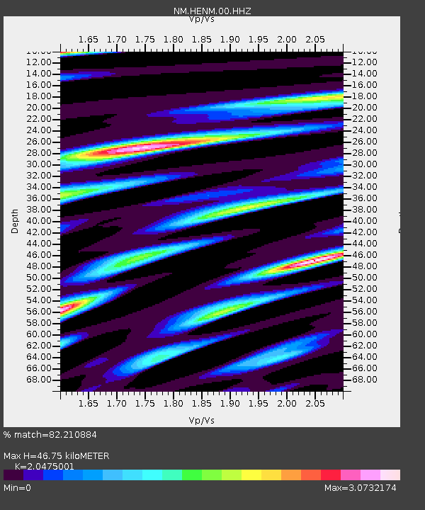
| Estimated Moho Depth: |
46.75 km |
| Estimated Crust Vp/Vs: |
2.05 |
| Assumed Crust Vp: |
6.444 km/s |
| Estimated Crust Vs: |
3.147 km/s |
| Estimated Crust Poisson's Ratio: |
0.34 |
|
| Radial Match: |
82.210884 % |
| Radial Bump: |
400 |
| Transverse Match: |
68.00625 % |
| Transverse Bump: |
400 |
| SOD ConfigId: |
29669891 |
| Insert Time: |
2022-11-16 06:08:01.298 +0000 |
| GWidth: |
2.5 |
| Max Bumps: |
400 |
| Tol: |
0.001 |
|

Signal To Noise
| Channel | StoN | STA | LTA |
| NM:HENM:00:HHZ:20221102T04:59:47.410Z | 2.1019032 | 6.75225E-7 | 3.2124458E-7 |
| NM:HENM:00:HHN:20221102T04:59:47.410Z | 0.74376756 | 4.300957E-7 | 5.782663E-7 |
| NM:HENM:00:HHE:20221102T04:59:47.410Z | 1.297084 | 6.013018E-7 | 4.635797E-7 |
| Arrivals |
| Ps | 8.1 SECOND |
| PpPs | 21 SECOND |
| PsPs/PpSs | 29 SECOND |


