You are here: Home > Network List > UW - Pacific Northwest Regional Seismic Network Stations List
> Station PASS Maple Falls, WA, USA > Earthquake Result Viewer
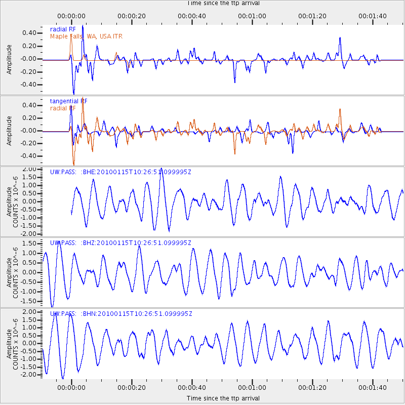
PASS Maple Falls, WA, USA - Earthquake Result Viewer
*The percent match for this event was below the threshold and hence no stack was calculated.
| Earthquake location: |
Kermadec Islands Region |
| Earthquake latitude/longitude: |
-31.7/-177.6 |
| Earthquake time(UTC): |
2010/01/15 (015) 10:14:02 GMT |
| Earthquake Depth: |
10 km |
| Earthquake Magnitude: |
5.9 MS, 5.4 MB, 5.9 MW |
| Earthquake Catalog/Contributor: |
WHDF/NEIC |
|
| Network: |
UW Pacific Northwest Regional Seismic Network |
| Station: |
PASS Maple Falls, WA, USA |
| Lat/Lon: |
49.00 N/122.09 W |
| Elevation: |
174 m |
|
| Distance: |
94.4 deg |
| Az: |
32.992 deg |
| Baz: |
224.792 deg |
| Ray Param: |
$rayparam |
*The percent match for this event was below the threshold and hence was not used in the summary stack. |
|
| Radial Match: |
65.59405 % |
| Radial Bump: |
331 |
| Transverse Match: |
72.3357 % |
| Transverse Bump: |
355 |
| SOD ConfigId: |
296938 |
| Insert Time: |
2010-04-06 20:02:01.062 +0000 |
| GWidth: |
2.5 |
| Max Bumps: |
400 |
| Tol: |
0.001 |
|
Signal To Noise
| Channel | StoN | STA | LTA |
| UW:PASS: :BHZ:20100115T10:26:51.099995Z | 0.9278968 | 6.413393E-7 | 6.911752E-7 |
| UW:PASS: :BHN:20100115T10:26:51.099995Z | 1.5083617 | 1.2815722E-6 | 8.4964506E-7 |
| UW:PASS: :BHE:20100115T10:26:51.099995Z | 1.6893574 | 1.1466755E-6 | 6.7876425E-7 |
| Arrivals |
| Ps | |
| PpPs | |
| PsPs/PpSs | |


