You are here: Home > Network List > OH - Ohio Seismic Network Stations List
> Station MFOH Malabar Farms > Earthquake Result Viewer
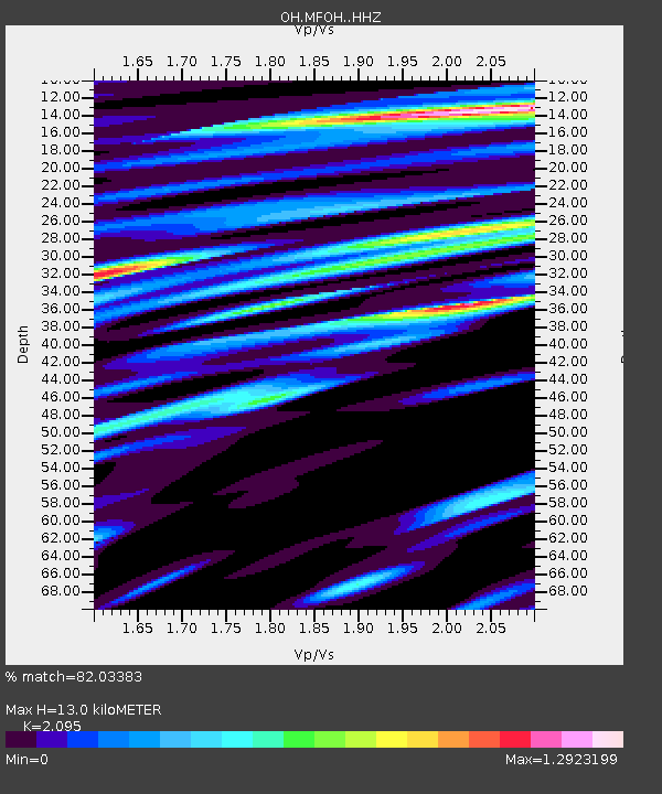
MFOH Malabar Farms - Earthquake Result Viewer
| Earthquake location: |
North Pacific Ocean |
| Earthquake latitude/longitude: |
31.5/-133.4 |
| Earthquake time(UTC): |
2022/11/02 (306) 04:53:13 GMT |
| Earthquake Depth: |
10 km |
| Earthquake Magnitude: |
6.0 mww |
| Earthquake Catalog/Contributor: |
NEIC PDE/us |
|
| Network: |
OH Ohio Seismic Network |
| Station: |
MFOH Malabar Farms |
| Lat/Lon: |
40.65 N/82.38 W |
| Elevation: |
374 m |
|
| Distance: |
41.7 deg |
| Az: |
62.694 deg |
| Baz: |
274.02 deg |
| Ray Param: |
0.07363383 |
| Estimated Moho Depth: |
13.0 km |
| Estimated Crust Vp/Vs: |
2.10 |
| Assumed Crust Vp: |
6.498 km/s |
| Estimated Crust Vs: |
3.101 km/s |
| Estimated Crust Poisson's Ratio: |
0.35 |
|
| Radial Match: |
82.03383 % |
| Radial Bump: |
400 |
| Transverse Match: |
82.78629 % |
| Transverse Bump: |
400 |
| SOD ConfigId: |
29669891 |
| Insert Time: |
2022-11-16 06:09:37.457 +0000 |
| GWidth: |
2.5 |
| Max Bumps: |
400 |
| Tol: |
0.001 |
|

Signal To Noise
| Channel | StoN | STA | LTA |
| OH:MFOH: :HHZ:20221102T05:00:31.114986Z | 4.2208476 | 1.4768382E-8 | 3.4989138E-9 |
| OH:MFOH: :HHN:20221102T05:00:31.114986Z | 1.1719488 | 1.6625558E-10 | 1.418625E-10 |
| OH:MFOH: :HHE:20221102T05:00:31.114986Z | 2.8776143 | 9.663692E-9 | 3.3582306E-9 |
| Arrivals |
| Ps | 2.3 SECOND |
| PpPs | 5.8 SECOND |
| PsPs/PpSs | 8.2 SECOND |


