You are here: Home > Network List > US - United States National Seismic Network Stations List
> Station GLMI Grayling, Michigan, USA > Earthquake Result Viewer
GLMI Grayling, Michigan, USA - Earthquake Result Viewer
| Earthquake location: |
North Pacific Ocean |
| Earthquake latitude/longitude: |
31.5/-133.4 |
| Earthquake time(UTC): |
2022/11/02 (306) 04:53:13 GMT |
| Earthquake Depth: |
10 km |
| Earthquake Magnitude: |
6.0 mww |
| Earthquake Catalog/Contributor: |
NEIC PDE/us |
|
| Network: |
US United States National Seismic Network |
| Station: |
GLMI Grayling, Michigan, USA |
| Lat/Lon: |
44.82 N/84.62 W |
| Elevation: |
387 m |
|
| Distance: |
40.0 deg |
| Az: |
56.359 deg |
| Baz: |
267.711 deg |
| Ray Param: |
0.07466368 |
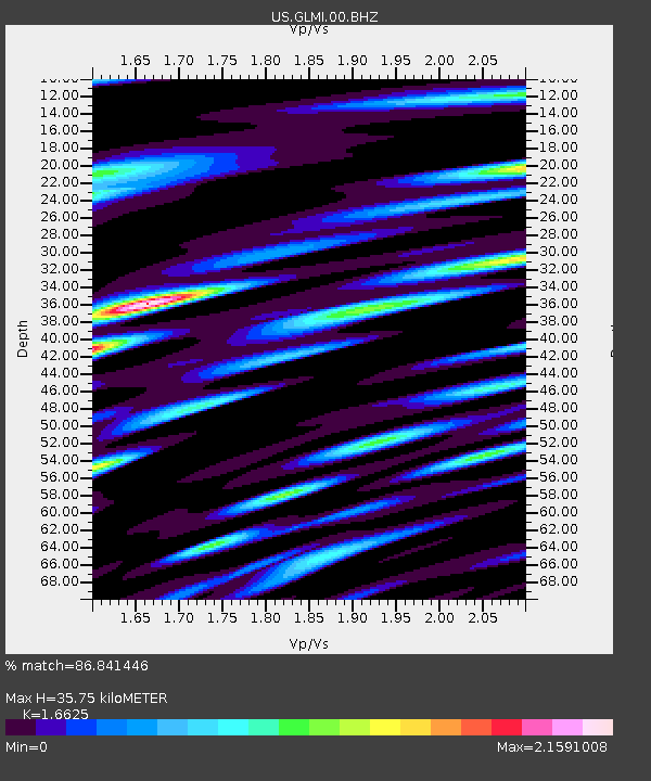
| Estimated Moho Depth: |
35.75 km |
| Estimated Crust Vp/Vs: |
1.66 |
| Assumed Crust Vp: |
6.483 km/s |
| Estimated Crust Vs: |
3.899 km/s |
| Estimated Crust Poisson's Ratio: |
0.22 |
|
| Radial Match: |
86.841446 % |
| Radial Bump: |
400 |
| Transverse Match: |
74.16989 % |
| Transverse Bump: |
400 |
| SOD ConfigId: |
29669891 |
| Insert Time: |
2022-11-16 06:13:03.215 +0000 |
| GWidth: |
2.5 |
| Max Bumps: |
400 |
| Tol: |
0.001 |
|

Signal To Noise
| Channel | StoN | STA | LTA |
| US:GLMI:00:BHZ:20221102T05:00:17.024013Z | 3.4301274 | 1.0429401E-6 | 3.0405286E-7 |
| US:GLMI:00:BH1:20221102T05:00:17.024013Z | 1.0858334 | 4.8652197E-7 | 4.4806316E-7 |
| US:GLMI:00:BH2:20221102T05:00:17.024013Z | 2.9414673 | 1.2008037E-6 | 4.082329E-7 |
| Arrivals |
| Ps | 3.9 SECOND |
| PpPs | 14 SECOND |
| PsPs/PpSs | 18 SECOND |


