You are here: Home > Network List > TM - Thai Seismic Monitoring Network Stations List
> Station PANO PANO staion > Earthquake Result Viewer
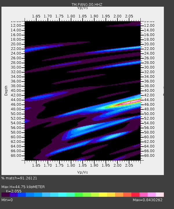
PANO PANO staion - Earthquake Result Viewer
| Earthquake location: |
Banda Sea |
| Earthquake latitude/longitude: |
-6.6/130.5 |
| Earthquake time(UTC): |
2022/11/03 (307) 18:46:44 GMT |
| Earthquake Depth: |
80 km |
| Earthquake Magnitude: |
5.3 Mww |
| Earthquake Catalog/Contributor: |
NEIC PDE/us |
|
| Network: |
TM Thai Seismic Monitoring Network |
| Station: |
PANO PANO staion |
| Lat/Lon: |
17.15 N/104.61 E |
| Elevation: |
136 m |
|
| Distance: |
34.8 deg |
| Az: |
312.955 deg |
| Baz: |
130.489 deg |
| Ray Param: |
0.07732854 |
| Estimated Moho Depth: |
44.75 km |
| Estimated Crust Vp/Vs: |
2.06 |
| Assumed Crust Vp: |
6.498 km/s |
| Estimated Crust Vs: |
3.162 km/s |
| Estimated Crust Poisson's Ratio: |
0.34 |
|
| Radial Match: |
91.26121 % |
| Radial Bump: |
400 |
| Transverse Match: |
86.436386 % |
| Transverse Bump: |
400 |
| SOD ConfigId: |
29669891 |
| Insert Time: |
2022-11-17 19:57:11.923 +0000 |
| GWidth: |
2.5 |
| Max Bumps: |
400 |
| Tol: |
0.001 |
|

Signal To Noise
| Channel | StoN | STA | LTA |
| TM:PANO:00:HHZ:20221103T18:52:57.340015Z | 52.10089 | 5.526206E-7 | 1.060674E-8 |
| TM:PANO:00:HHN:20221103T18:52:57.340015Z | 3.949413 | 4.0557623E-8 | 1.0269279E-8 |
| TM:PANO:00:HHE:20221103T18:52:57.340015Z | 16.634954 | 1.7836257E-7 | 1.0722156E-8 |
| Arrivals |
| Ps | 7.8 SECOND |
| PpPs | 20 SECOND |
| PsPs/PpSs | 27 SECOND |


