You are here: Home > Network List > IW - Intermountain West Stations List
> Station MOOW Moose Ponds, Wyoming, USA > Earthquake Result Viewer
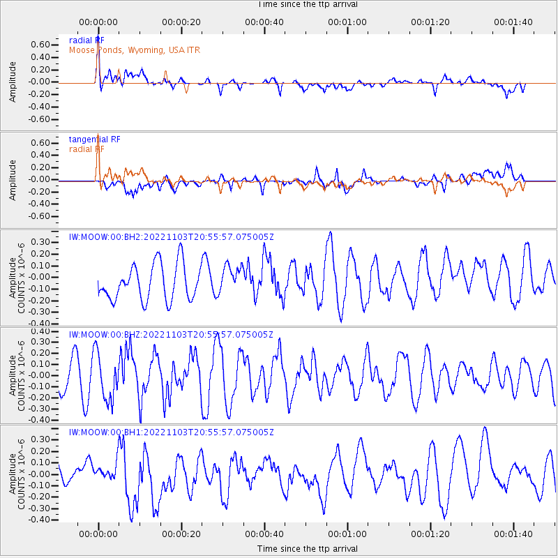
MOOW Moose Ponds, Wyoming, USA - Earthquake Result Viewer
*The percent match for this event was below the threshold and hence no stack was calculated.
| Earthquake location: |
Reykjanes Ridge |
| Earthquake latitude/longitude: |
53.8/-35.5 |
| Earthquake time(UTC): |
2022/11/03 (307) 20:47:46 GMT |
| Earthquake Depth: |
10 km |
| Earthquake Magnitude: |
5.4 Mww |
| Earthquake Catalog/Contributor: |
NEIC PDE/us |
|
| Network: |
IW Intermountain West |
| Station: |
MOOW Moose Ponds, Wyoming, USA |
| Lat/Lon: |
43.75 N/110.74 W |
| Elevation: |
2128 m |
|
| Distance: |
48.4 deg |
| Az: |
290.365 deg |
| Baz: |
50.135 deg |
| Ray Param: |
$rayparam |
*The percent match for this event was below the threshold and hence was not used in the summary stack. |
|
| Radial Match: |
46.62903 % |
| Radial Bump: |
400 |
| Transverse Match: |
61.988228 % |
| Transverse Bump: |
400 |
| SOD ConfigId: |
29669891 |
| Insert Time: |
2022-11-17 22:05:07.319 +0000 |
| GWidth: |
2.5 |
| Max Bumps: |
400 |
| Tol: |
0.001 |
|
Signal To Noise
| Channel | StoN | STA | LTA |
| IW:MOOW:00:BHZ:20221103T20:55:57.075005Z | 1.3934643 | 2.0953793E-7 | 1.5037193E-7 |
| IW:MOOW:00:BH1:20221103T20:55:57.075005Z | 0.7252374 | 7.722046E-8 | 1.0647611E-7 |
| IW:MOOW:00:BH2:20221103T20:55:57.075005Z | 0.80697614 | 1.2301035E-7 | 1.524337E-7 |
| Arrivals |
| Ps | |
| PpPs | |
| PsPs/PpSs | |


