You are here: Home > Network List > CM - Red Sismologica Nacional de Columbia Stations List
> Station SMAR Santa Marta, Magdalena, Colombia > Earthquake Result Viewer
SMAR Santa Marta, Magdalena, Colombia - Earthquake Result Viewer
| Earthquake location: |
Gulf Of California |
| Earthquake latitude/longitude: |
28.2/-112.3 |
| Earthquake time(UTC): |
2022/11/04 (308) 10:02:46 GMT |
| Earthquake Depth: |
10 km |
| Earthquake Magnitude: |
6.1 mww |
| Earthquake Catalog/Contributor: |
NEIC PDE/us |
|
| Network: |
CM Red Sismologica Nacional de Columbia |
| Station: |
SMAR Santa Marta, Magdalena, Colombia |
| Lat/Lon: |
11.16 N/74.22 W |
| Elevation: |
122 m |
|
| Distance: |
39.4 deg |
| Az: |
107.687 deg |
| Baz: |
301.007 deg |
| Ray Param: |
0.07499476 |
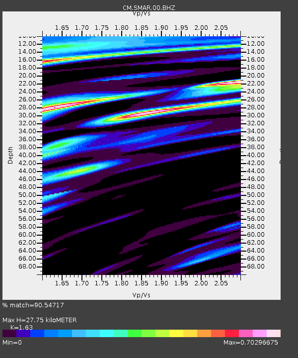
| Estimated Moho Depth: |
27.75 km |
| Estimated Crust Vp/Vs: |
1.63 |
| Assumed Crust Vp: |
5.129 km/s |
| Estimated Crust Vs: |
3.147 km/s |
| Estimated Crust Poisson's Ratio: |
0.20 |
|
| Radial Match: |
90.54717 % |
| Radial Bump: |
400 |
| Transverse Match: |
73.0064 % |
| Transverse Bump: |
400 |
| SOD ConfigId: |
29669891 |
| Insert Time: |
2022-11-18 11:10:20.280 +0000 |
| GWidth: |
2.5 |
| Max Bumps: |
400 |
| Tol: |
0.001 |
|

Signal To Noise
| Channel | StoN | STA | LTA |
| CM:SMAR:00:BHZ:20221104T10:09:45.968998Z | 3.5657916 | 4.378673E-7 | 1.2279666E-7 |
| CM:SMAR:00:BHN:20221104T10:09:45.968998Z | 1.6879703 | 1.9119061E-7 | 1.1326657E-7 |
| CM:SMAR:00:BHE:20221104T10:09:45.968998Z | 1.381141 | 1.5512482E-7 | 1.1231642E-7 |
| Arrivals |
| Ps | 3.6 SECOND |
| PpPs | 14 SECOND |
| PsPs/PpSs | 17 SECOND |


