You are here: Home > Network List > TA - USArray Transportable Network (new EarthScope stations) Stations List
> Station W27A Bowe Ranch, Endee, NM, USA > Earthquake Result Viewer
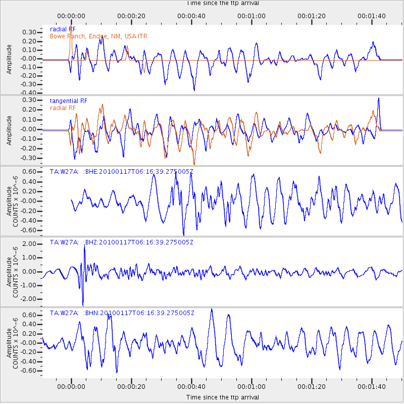
W27A Bowe Ranch, Endee, NM, USA - Earthquake Result Viewer
*The percent match for this event was below the threshold and hence no stack was calculated.
| Earthquake location: |
Off East Coast Of Honshu, Japan |
| Earthquake latitude/longitude: |
37.9/143.6 |
| Earthquake time(UTC): |
2010/01/17 (017) 06:04:36 GMT |
| Earthquake Depth: |
7.0 km |
| Earthquake Magnitude: |
5.7 MB, 5.2 MS, 5.6 MW, 5.6 MW |
| Earthquake Catalog/Contributor: |
WHDF/NEIC |
|
| Network: |
TA USArray Transportable Network (new EarthScope stations) |
| Station: |
W27A Bowe Ranch, Endee, NM, USA |
| Lat/Lon: |
35.06 N/103.06 W |
| Elevation: |
1233 m |
|
| Distance: |
84.7 deg |
| Az: |
49.156 deg |
| Baz: |
313.184 deg |
| Ray Param: |
$rayparam |
*The percent match for this event was below the threshold and hence was not used in the summary stack. |
|
| Radial Match: |
46.995438 % |
| Radial Bump: |
400 |
| Transverse Match: |
41.947155 % |
| Transverse Bump: |
400 |
| SOD ConfigId: |
296938 |
| Insert Time: |
2010-04-06 20:26:04.734 +0000 |
| GWidth: |
2.5 |
| Max Bumps: |
400 |
| Tol: |
0.001 |
|
Signal To Noise
| Channel | StoN | STA | LTA |
| TA:W27A: :BHZ:20100117T06:16:39.275005Z | 5.196125 | 8.077142E-7 | 1.5544549E-7 |
| TA:W27A: :BHN:20100117T06:16:39.275005Z | 0.8082046 | 2.1566494E-7 | 2.668445E-7 |
| TA:W27A: :BHE:20100117T06:16:39.275005Z | 2.4315877 | 2.857519E-7 | 1.1751659E-7 |
| Arrivals |
| Ps | |
| PpPs | |
| PsPs/PpSs | |


