You are here: Home > Network List > TA - USArray Transportable Network (new EarthScope stations) Stations List
> Station I20A Worland, WY, USA > Earthquake Result Viewer
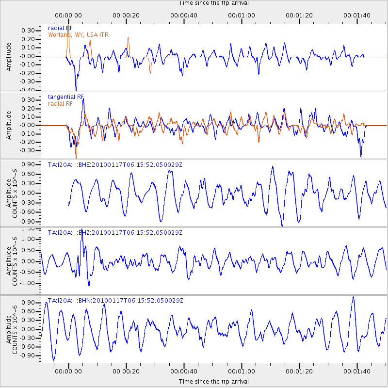
I20A Worland, WY, USA - Earthquake Result Viewer
*The percent match for this event was below the threshold and hence no stack was calculated.
| Earthquake location: |
Off East Coast Of Honshu, Japan |
| Earthquake latitude/longitude: |
37.9/143.6 |
| Earthquake time(UTC): |
2010/01/17 (017) 06:04:36 GMT |
| Earthquake Depth: |
7.0 km |
| Earthquake Magnitude: |
5.7 MB, 5.2 MS, 5.6 MW, 5.6 MW |
| Earthquake Catalog/Contributor: |
WHDF/NEIC |
|
| Network: |
TA USArray Transportable Network (new EarthScope stations) |
| Station: |
I20A Worland, WY, USA |
| Lat/Lon: |
43.95 N/108.13 W |
| Elevation: |
1342 m |
|
| Distance: |
75.9 deg |
| Az: |
45.016 deg |
| Baz: |
309.26 deg |
| Ray Param: |
$rayparam |
*The percent match for this event was below the threshold and hence was not used in the summary stack. |
|
| Radial Match: |
56.62749 % |
| Radial Bump: |
400 |
| Transverse Match: |
71.97899 % |
| Transverse Bump: |
400 |
| SOD ConfigId: |
296938 |
| Insert Time: |
2010-04-06 20:27:38.099 +0000 |
| GWidth: |
2.5 |
| Max Bumps: |
400 |
| Tol: |
0.001 |
|
Signal To Noise
| Channel | StoN | STA | LTA |
| TA:I20A: :BHZ:20100117T06:15:52.050029Z | 1.6225231 | 5.5715213E-7 | 3.4338626E-7 |
| TA:I20A: :BHN:20100117T06:15:52.050029Z | 1.2752346 | 4.6908283E-7 | 3.6784044E-7 |
| TA:I20A: :BHE:20100117T06:15:52.050029Z | 1.5546861 | 5.129546E-7 | 3.2994095E-7 |
| Arrivals |
| Ps | |
| PpPs | |
| PsPs/PpSs | |


