You are here: Home > Network List > TA - USArray Transportable Network (new EarthScope stations) Stations List
> Station X29A Tulia, tX, USA > Earthquake Result Viewer
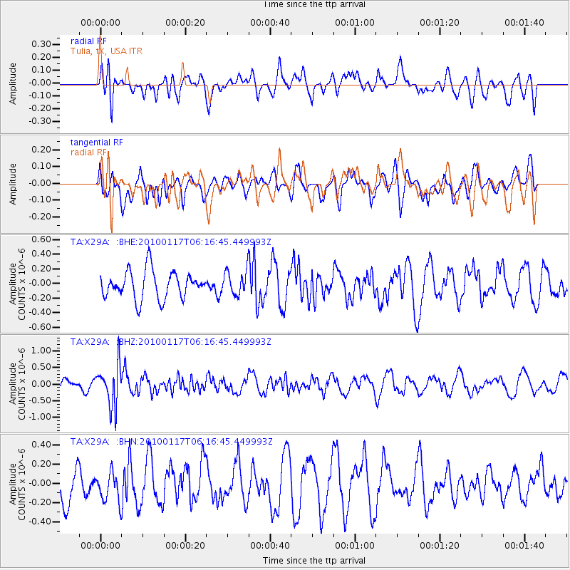
X29A Tulia, tX, USA - Earthquake Result Viewer
*The percent match for this event was below the threshold and hence no stack was calculated.
| Earthquake location: |
Off East Coast Of Honshu, Japan |
| Earthquake latitude/longitude: |
37.9/143.6 |
| Earthquake time(UTC): |
2010/01/17 (017) 06:04:36 GMT |
| Earthquake Depth: |
7.0 km |
| Earthquake Magnitude: |
5.7 MB, 5.2 MS, 5.6 MW, 5.6 MW |
| Earthquake Catalog/Contributor: |
WHDF/NEIC |
|
| Network: |
TA USArray Transportable Network (new EarthScope stations) |
| Station: |
X29A Tulia, tX, USA |
| Lat/Lon: |
34.45 N/101.70 W |
| Elevation: |
1039 m |
|
| Distance: |
85.9 deg |
| Az: |
48.83 deg |
| Baz: |
313.93 deg |
| Ray Param: |
$rayparam |
*The percent match for this event was below the threshold and hence was not used in the summary stack. |
|
| Radial Match: |
54.76872 % |
| Radial Bump: |
400 |
| Transverse Match: |
47.066563 % |
| Transverse Bump: |
400 |
| SOD ConfigId: |
296938 |
| Insert Time: |
2010-04-06 20:31:13.989 +0000 |
| GWidth: |
2.5 |
| Max Bumps: |
400 |
| Tol: |
0.001 |
|
Signal To Noise
| Channel | StoN | STA | LTA |
| TA:X29A: :BHZ:20100117T06:16:45.449993Z | 2.7957554 | 6.16921E-7 | 2.2066344E-7 |
| TA:X29A: :BHN:20100117T06:16:45.449993Z | 0.9201574 | 1.6451344E-7 | 1.7878838E-7 |
| TA:X29A: :BHE:20100117T06:16:45.449993Z | 0.9066532 | 1.7207005E-7 | 1.8978595E-7 |
| Arrivals |
| Ps | |
| PpPs | |
| PsPs/PpSs | |


