You are here: Home > Network List > TA - USArray Transportable Network (new EarthScope stations) Stations List
> Station Z32A Haskell, TX, USA > Earthquake Result Viewer
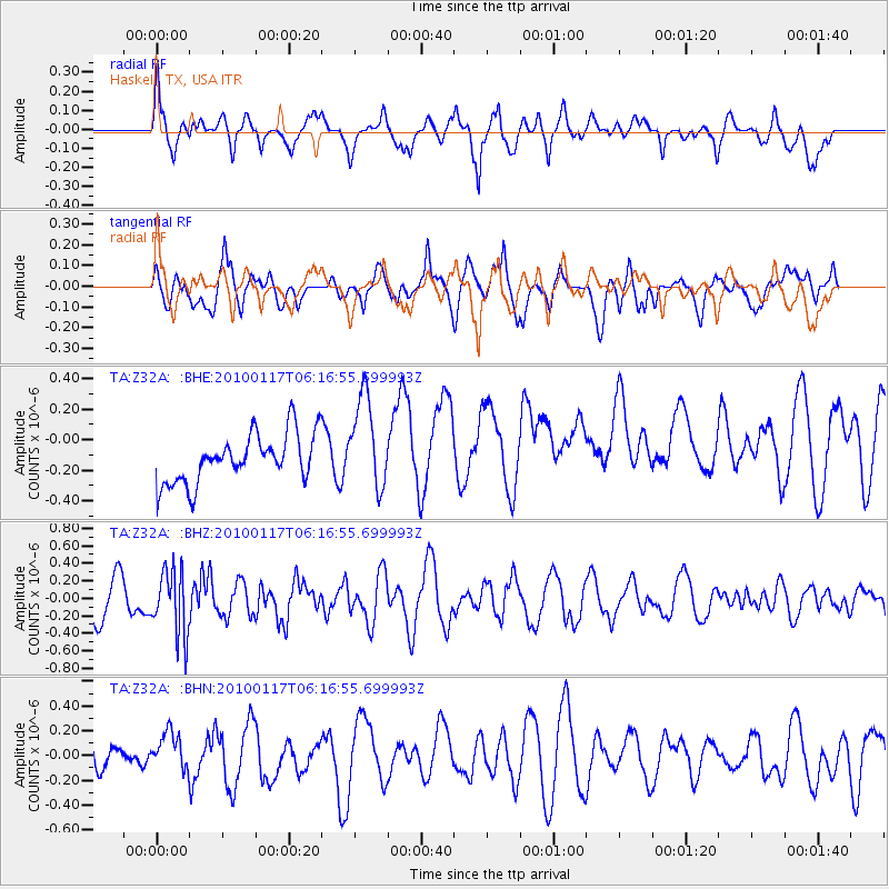
Z32A Haskell, TX, USA - Earthquake Result Viewer
*The percent match for this event was below the threshold and hence no stack was calculated.
| Earthquake location: |
Off East Coast Of Honshu, Japan |
| Earthquake latitude/longitude: |
37.9/143.6 |
| Earthquake time(UTC): |
2010/01/17 (017) 06:04:36 GMT |
| Earthquake Depth: |
7.0 km |
| Earthquake Magnitude: |
5.7 MB, 5.2 MS, 5.6 MW, 5.6 MW |
| Earthquake Catalog/Contributor: |
WHDF/NEIC |
|
| Network: |
TA USArray Transportable Network (new EarthScope stations) |
| Station: |
Z32A Haskell, TX, USA |
| Lat/Lon: |
33.31 N/99.48 W |
| Elevation: |
427 m |
|
| Distance: |
88.0 deg |
| Az: |
48.342 deg |
| Baz: |
315.138 deg |
| Ray Param: |
$rayparam |
*The percent match for this event was below the threshold and hence was not used in the summary stack. |
|
| Radial Match: |
59.788094 % |
| Radial Bump: |
400 |
| Transverse Match: |
54.170155 % |
| Transverse Bump: |
400 |
| SOD ConfigId: |
296938 |
| Insert Time: |
2010-04-06 20:31:56.443 +0000 |
| GWidth: |
2.5 |
| Max Bumps: |
400 |
| Tol: |
0.001 |
|
Signal To Noise
| Channel | StoN | STA | LTA |
| TA:Z32A: :BHZ:20100117T06:16:55.699993Z | 2.0950823 | 3.6675476E-7 | 1.7505506E-7 |
| TA:Z32A: :BHN:20100117T06:16:55.699993Z | 0.9193299 | 1.6743748E-7 | 1.8212991E-7 |
| TA:Z32A: :BHE:20100117T06:16:55.699993Z | 1.9362168 | 3.100663E-7 | 1.6014029E-7 |
| Arrivals |
| Ps | |
| PpPs | |
| PsPs/PpSs | |


