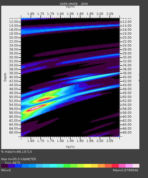
MM09 East Canton, Ohio - Earthquake Result Viewer

Earthquake location: Peru-Ecuador Border Region
Earthquake latitude/longitude: -2.8/-77.9
Earthquake time(UTC): 1995/10/03 (276) 01:51:24 GMT
Earthquake Depth: 27 km
Earthquake Magnitude: 6.5 MB, 7.0 MS, 6.9 UNKNOWN, 7.0 MW
Earthquake Catalog/Contributor: WHDF/NEIC
Network: XA Missouri to Massachusetts Transect
Station: MM09 East Canton, Ohio
Lat/Lon: 40.79 N/81.21 W
Elevation: 357 m
Distance: 43.5 deg
Az: 356.333 deg
Baz: 175.174 deg
Ray Param: 0.072488055
Estimated Moho Depth: 55.5 km
Estimated Crust Vp/Vs: 1.67
Assumed Crust Vp: 6.483 km/s
Estimated Crust Vs: 3.888 km/s
Estimated Crust Poisson's Ratio: 0.22
Radial Match: 96.18714 %
Radial Bump: 258
Transverse Match: 84.85485 %
Transverse Bump: 400
SOD ConfigId: 6273
Insert Time: 2010-02-26 17:49:53.467 +0000
GWidth: 2.5
Max Bumps: 400
Tol: 0.001

Signal To Noise

ChannelStoNSTALTA
XA:MM09: :BHN:19951003T01:58:54.126001Z3.63298657.459783E-72.0533473E-7
XA:MM09: :BHE:19951003T01:58:54.126001Z0.54849941.1915683E-72.1724149E-7
XA:MM09: :BHZ:19951003T01:58:54.126001Z4.52512261.5281025E-63.3769308E-7
Arrivals
Ps6.1 SECOND
PpPs21 SECOND
PsPs/PpSs27 SECOND