You are here: Home > Network List > CI - Caltech Regional Seismic Network Stations List
> Station GLA Glamis, Glamis, CA, USA > Earthquake Result Viewer
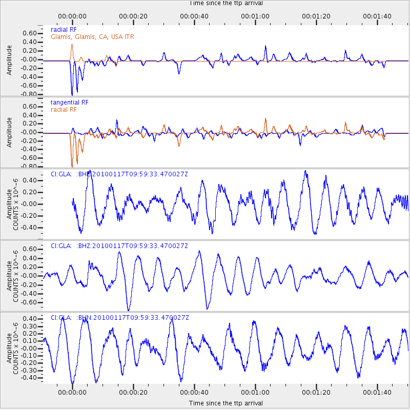
GLA Glamis, Glamis, CA, USA - Earthquake Result Viewer
*The percent match for this event was below the threshold and hence no stack was calculated.
| Earthquake location: |
New Britain Region, P.N.G. |
| Earthquake latitude/longitude: |
-6.1/152.6 |
| Earthquake time(UTC): |
2010/01/17 (017) 09:46:40 GMT |
| Earthquake Depth: |
10 km |
| Earthquake Magnitude: |
5.5 MB, 5.1 MS, 5.7 MW, 5.7 MW |
| Earthquake Catalog/Contributor: |
WHDF/NEIC |
|
| Network: |
CI Caltech Regional Seismic Network |
| Station: |
GLA Glamis, Glamis, CA, USA |
| Lat/Lon: |
33.05 N/114.83 W |
| Elevation: |
610 m |
|
| Distance: |
95.5 deg |
| Az: |
57.439 deg |
| Baz: |
266.278 deg |
| Ray Param: |
$rayparam |
*The percent match for this event was below the threshold and hence was not used in the summary stack. |
|
| Radial Match: |
73.72742 % |
| Radial Bump: |
400 |
| Transverse Match: |
59.560497 % |
| Transverse Bump: |
383 |
| SOD ConfigId: |
296938 |
| Insert Time: |
2010-04-06 20:41:32.305 +0000 |
| GWidth: |
2.5 |
| Max Bumps: |
400 |
| Tol: |
0.001 |
|
Signal To Noise
| Channel | StoN | STA | LTA |
| CI:GLA: :BHZ:20100117T09:59:33.470027Z | 0.90988123 | 1.7227386E-7 | 1.8933665E-7 |
| CI:GLA: :BHN:20100117T09:59:33.470027Z | 3.4213192 | 3.3315678E-7 | 9.73767E-8 |
| CI:GLA: :BHE:20100117T09:59:33.470027Z | 0.59965014 | 1.3994456E-7 | 2.3337701E-7 |
| Arrivals |
| Ps | |
| PpPs | |
| PsPs/PpSs | |


