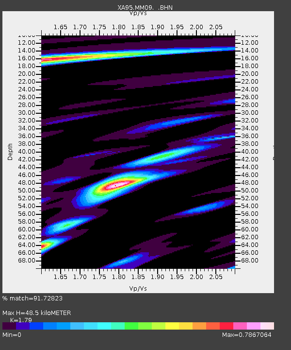
MM09 East Canton, Ohio - Earthquake Result Viewer
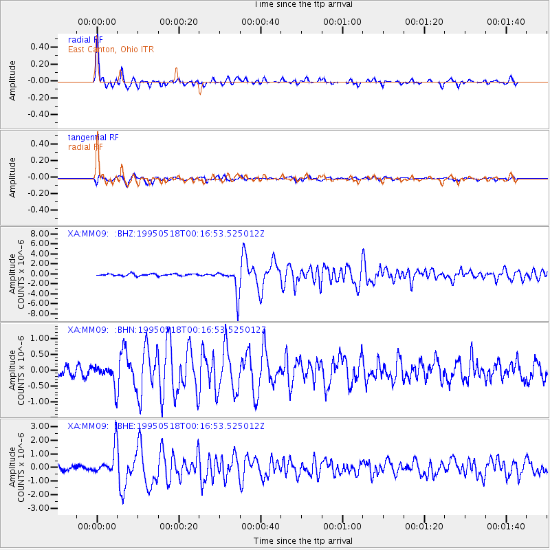
Earthquake location: Central Mid-Atlantic Ridge
Earthquake latitude/longitude: -0.9/-22.0
Earthquake time(UTC): 1995/05/18 (138) 00:06:26 GMT
Earthquake Depth: 10 km
Earthquake Magnitude: 6.2 MB, 6.1 MS, 6.8 UNKNOWN, 6.7 MW
Earthquake Catalog/Contributor: WHDF/NEIC
Network: XA Missouri to Massachusetts Transect
Station: MM09 East Canton, Ohio
Lat/Lon: 40.79 N/81.21 W
Elevation: 357 m
Distance: 67.8 deg
Az: 315.209 deg
Baz: 111.909 deg
Ray Param: 0.056717597
Estimated Moho Depth: 48.5 km
Estimated Crust Vp/Vs: 1.79
Assumed Crust Vp: 6.483 km/s
Estimated Crust Vs: 3.622 km/s
Estimated Crust Poisson's Ratio: 0.27
Radial Match: 91.72823 %
Radial Bump: 343
Transverse Match: 83.443855 %
Transverse Bump: 400
SOD ConfigId: 6273
Insert Time: 2010-02-26 17:49:57.415 +0000
GWidth: 2.5
Max Bumps: 400
Tol: 0.001

Signal To Noise

ChannelStoNSTALTA
XA:MM09: :BHN:19950518T00:16:53.525012Z1.96601773.2225165E-71.6391085E-7
XA:MM09: :BHE:19950518T00:16:53.525012Z6.11711451.0548163E-61.7243688E-7
XA:MM09: :BHZ:19950518T00:16:53.525012Z14.0163442.7634708E-61.971606E-7
Arrivals
Ps6.1 SECOND
PpPs20 SECOND
PsPs/PpSs26 SECOND