You are here: Home > Network List > TA - USArray Transportable Network (new EarthScope stations) Stations List
> Station Y14A Wickenburg, AZ, USA > Earthquake Result Viewer
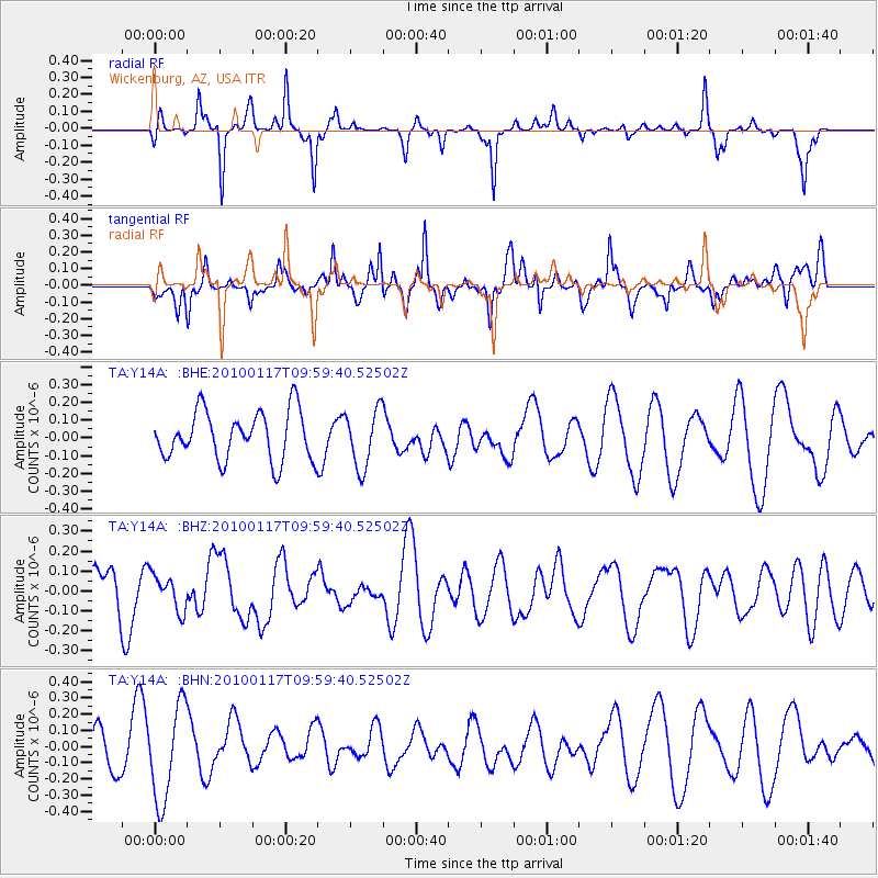
Y14A Wickenburg, AZ, USA - Earthquake Result Viewer
*The percent match for this event was below the threshold and hence no stack was calculated.
| Earthquake location: |
New Britain Region, P.N.G. |
| Earthquake latitude/longitude: |
-6.1/152.6 |
| Earthquake time(UTC): |
2010/01/17 (017) 09:46:40 GMT |
| Earthquake Depth: |
10 km |
| Earthquake Magnitude: |
5.5 MB, 5.1 MS, 5.7 MW, 5.7 MW |
| Earthquake Catalog/Contributor: |
WHDF/NEIC |
|
| Network: |
TA USArray Transportable Network (new EarthScope stations) |
| Station: |
Y14A Wickenburg, AZ, USA |
| Lat/Lon: |
33.94 N/113.00 W |
| Elevation: |
731 m |
|
| Distance: |
97.0 deg |
| Az: |
56.636 deg |
| Baz: |
267.366 deg |
| Ray Param: |
$rayparam |
*The percent match for this event was below the threshold and hence was not used in the summary stack. |
|
| Radial Match: |
49.772842 % |
| Radial Bump: |
181 |
| Transverse Match: |
49.645084 % |
| Transverse Bump: |
395 |
| SOD ConfigId: |
296938 |
| Insert Time: |
2010-04-06 20:44:48.640 +0000 |
| GWidth: |
2.5 |
| Max Bumps: |
400 |
| Tol: |
0.001 |
|
Signal To Noise
| Channel | StoN | STA | LTA |
| TA:Y14A: :BHZ:20100117T09:59:40.52502Z | 1.1149566 | 8.9438224E-8 | 8.021677E-8 |
| TA:Y14A: :BHN:20100117T09:59:40.52502Z | 1.8613309 | 2.9296072E-7 | 1.5739316E-7 |
| TA:Y14A: :BHE:20100117T09:59:40.52502Z | 1.2021289 | 1.6288205E-7 | 1.3549466E-7 |
| Arrivals |
| Ps | |
| PpPs | |
| PsPs/PpSs | |


