You are here: Home > Network List > US - United States National Seismic Network Stations List
> Station NEW Newport, Washington, USA > Earthquake Result Viewer
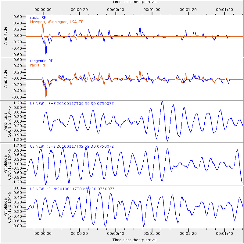
NEW Newport, Washington, USA - Earthquake Result Viewer
*The percent match for this event was below the threshold and hence no stack was calculated.
| Earthquake location: |
New Britain Region, P.N.G. |
| Earthquake latitude/longitude: |
-6.1/152.6 |
| Earthquake time(UTC): |
2010/01/17 (017) 09:46:40 GMT |
| Earthquake Depth: |
10 km |
| Earthquake Magnitude: |
5.5 MB, 5.1 MS, 5.7 MW, 5.7 MW |
| Earthquake Catalog/Contributor: |
WHDF/NEIC |
|
| Network: |
US United States National Seismic Network |
| Station: |
NEW Newport, Washington, USA |
| Lat/Lon: |
48.26 N/117.12 W |
| Elevation: |
760 m |
|
| Distance: |
94.7 deg |
| Az: |
42.102 deg |
| Baz: |
266.145 deg |
| Ray Param: |
$rayparam |
*The percent match for this event was below the threshold and hence was not used in the summary stack. |
|
| Radial Match: |
74.498604 % |
| Radial Bump: |
400 |
| Transverse Match: |
66.06398 % |
| Transverse Bump: |
400 |
| SOD ConfigId: |
296938 |
| Insert Time: |
2010-04-06 20:45:24.369 +0000 |
| GWidth: |
2.5 |
| Max Bumps: |
400 |
| Tol: |
0.001 |
|
Signal To Noise
| Channel | StoN | STA | LTA |
| US:NEW: :BHZ:20100117T09:59:30.075007Z | 3.74946 | 8.515047E-7 | 2.2710061E-7 |
| US:NEW: :BHN:20100117T09:59:30.075007Z | 1.5811437 | 2.5313358E-7 | 1.6009524E-7 |
| US:NEW: :BHE:20100117T09:59:30.075007Z | 1.298884 | 4.3323115E-7 | 3.3354104E-7 |
| Arrivals |
| Ps | |
| PpPs | |
| PsPs/PpSs | |


