You are here: Home > Network List > XA95 - Missouri to Massachusetts Transect Stations List
> Station MM09 East Canton, Ohio > Earthquake Result Viewer
MM09 East Canton, Ohio - Earthquake Result Viewer
| Earthquake location: |
Kuril Islands |
| Earthquake latitude/longitude: |
45.9/151.3 |
| Earthquake time(UTC): |
1995/04/17 (107) 23:28:08 GMT |
| Earthquake Depth: |
34 km |
| Earthquake Magnitude: |
6.1 MB, 6.3 MS, 6.2 UNKNOWN, 6.8 MW |
| Earthquake Catalog/Contributor: |
WHDF/NEIC |
|
| Network: |
XA Missouri to Massachusetts Transect |
| Station: |
MM09 East Canton, Ohio |
| Lat/Lon: |
40.79 N/81.21 W |
| Elevation: |
357 m |
|
| Distance: |
81.8 deg |
| Az: |
37.486 deg |
| Baz: |
325.966 deg |
| Ray Param: |
0.047302842 |
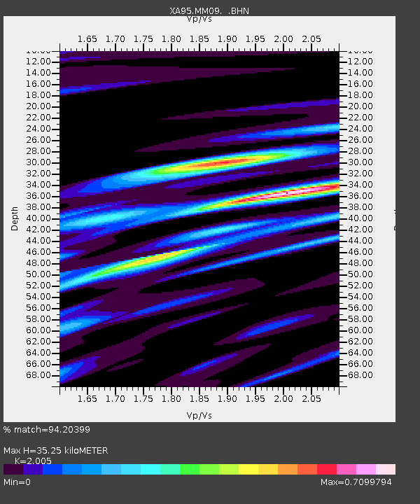
| Estimated Moho Depth: |
35.25 km |
| Estimated Crust Vp/Vs: |
2.01 |
| Assumed Crust Vp: |
6.483 km/s |
| Estimated Crust Vs: |
3.233 km/s |
| Estimated Crust Poisson's Ratio: |
0.33 |
|
| Radial Match: |
94.20399 % |
| Radial Bump: |
380 |
| Transverse Match: |
72.33181 % |
| Transverse Bump: |
400 |
| SOD ConfigId: |
6273 |
| Insert Time: |
2010-02-26 17:50:01.562 +0000 |
| GWidth: |
2.5 |
| Max Bumps: |
400 |
| Tol: |
0.001 |
|
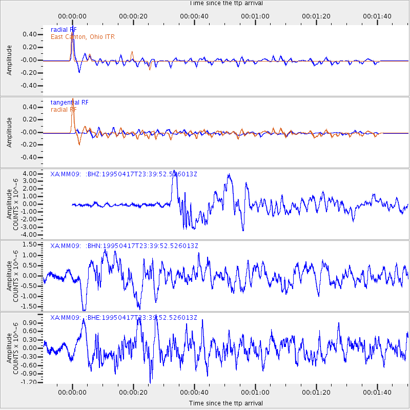
Signal To Noise
| Channel | StoN | STA | LTA |
| XA:MM09: :BHN:19950417T23:39:52.526013Z | 4.551746 | 8.253251E-7 | 1.8132056E-7 |
| XA:MM09: :BHE:19950417T23:39:52.526013Z | 3.7661657 | 5.3224846E-7 | 1.413237E-7 |
| XA:MM09: :BHZ:19950417T23:39:52.526013Z | 16.890236 | 2.1752687E-6 | 1.2878853E-7 |
| Arrivals |
| Ps | 5.6 SECOND |
| PpPs | 16 SECOND |
| PsPs/PpSs | 22 SECOND |


