You are here: Home > Network List > AU - Australian Seismological Centre Stations List
> Station PSAA1 Pilbara Seismic Array Element A1 > Earthquake Result Viewer
PSAA1 Pilbara Seismic Array Element A1 - Earthquake Result Viewer
| Earthquake location: |
South Of Fiji Islands |
| Earthquake latitude/longitude: |
-26.0/178.4 |
| Earthquake time(UTC): |
2022/11/09 (313) 09:38:42 GMT |
| Earthquake Depth: |
629 km |
| Earthquake Magnitude: |
6.8 mww |
| Earthquake Catalog/Contributor: |
NEIC PDE/us |
|
| Network: |
AU Australian Seismological Centre |
| Station: |
PSAA1 Pilbara Seismic Array Element A1 |
| Lat/Lon: |
21.58 S/119.84 E |
| Elevation: |
325 m |
|
| Distance: |
53.4 deg |
| Az: |
261.581 deg |
| Baz: |
106.917 deg |
| Ray Param: |
0.063305095 |
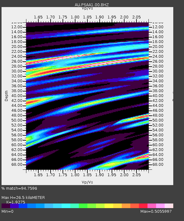
| Estimated Moho Depth: |
26.5 km |
| Estimated Crust Vp/Vs: |
1.93 |
| Assumed Crust Vp: |
6.464 km/s |
| Estimated Crust Vs: |
3.353 km/s |
| Estimated Crust Poisson's Ratio: |
0.32 |
|
| Radial Match: |
94.7596 % |
| Radial Bump: |
309 |
| Transverse Match: |
72.977875 % |
| Transverse Bump: |
400 |
| SOD ConfigId: |
29734672 |
| Insert Time: |
2022-11-23 09:45:19.858 +0000 |
| GWidth: |
2.5 |
| Max Bumps: |
400 |
| Tol: |
0.001 |
|

Signal To Noise
| Channel | StoN | STA | LTA |
| AU:PSAA1:00:BHZ:20221109T09:46:34.794011Z | 26.144285 | 6.441797E-6 | 2.4639408E-7 |
| AU:PSAA1:00:BH1:20221109T09:46:34.794011Z | 9.675939 | 1.5752585E-6 | 1.6280161E-7 |
| AU:PSAA1:00:BH2:20221109T09:46:34.794011Z | 31.565279 | 3.0900376E-6 | 9.789356E-8 |
| Arrivals |
| Ps | 4.0 SECOND |
| PpPs | 11 SECOND |
| PsPs/PpSs | 15 SECOND |


