You are here: Home > Network List > XA95 - Missouri to Massachusetts Transect Stations List
> Station MM09 East Canton, Ohio > Earthquake Result Viewer
MM09 East Canton, Ohio - Earthquake Result Viewer
| Earthquake location: |
Northern Peru |
| Earthquake latitude/longitude: |
-3.9/-77.0 |
| Earthquake time(UTC): |
1995/05/02 (122) 06:06:05 GMT |
| Earthquake Depth: |
103 km |
| Earthquake Magnitude: |
6.5 MB, 6.7 UNKNOWN, 6.6 MW |
| Earthquake Catalog/Contributor: |
WHDF/NEIC |
|
| Network: |
XA Missouri to Massachusetts Transect |
| Station: |
MM09 East Canton, Ohio |
| Lat/Lon: |
40.79 N/81.21 W |
| Elevation: |
357 m |
|
| Distance: |
44.6 deg |
| Az: |
355.406 deg |
| Baz: |
173.958 deg |
| Ray Param: |
0.07146602 |
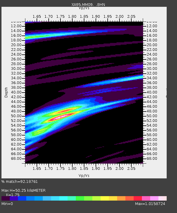
| Estimated Moho Depth: |
50.25 km |
| Estimated Crust Vp/Vs: |
1.75 |
| Assumed Crust Vp: |
6.483 km/s |
| Estimated Crust Vs: |
3.704 km/s |
| Estimated Crust Poisson's Ratio: |
0.26 |
|
| Radial Match: |
92.18761 % |
| Radial Bump: |
340 |
| Transverse Match: |
74.85103 % |
| Transverse Bump: |
400 |
| SOD ConfigId: |
6273 |
| Insert Time: |
2010-02-26 17:50:06.492 +0000 |
| GWidth: |
2.5 |
| Max Bumps: |
400 |
| Tol: |
0.001 |
|
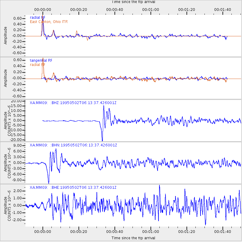
Signal To Noise
| Channel | StoN | STA | LTA |
| XA:MM09: :BHN:19950502T06:13:37.426001Z | 19.587858 | 4.101935E-6 | 2.0941211E-7 |
| XA:MM09: :BHE:19950502T06:13:37.426001Z | 2.9332998 | 5.1385933E-7 | 1.7518133E-7 |
| XA:MM09: :BHZ:19950502T06:13:37.426001Z | 33.04161 | 8.038317E-6 | 2.432786E-7 |
| Arrivals |
| Ps | 6.2 SECOND |
| PpPs | 20 SECOND |
| PsPs/PpSs | 26 SECOND |


