You are here: Home > Network List > XA95 - Missouri to Massachusetts Transect Stations List
> Station MM09 East Canton, Ohio > Earthquake Result Viewer
MM09 East Canton, Ohio - Earthquake Result Viewer
| Earthquake location: |
Greece |
| Earthquake latitude/longitude: |
40.1/21.7 |
| Earthquake time(UTC): |
1995/05/13 (133) 08:47:12 GMT |
| Earthquake Depth: |
13 km |
| Earthquake Magnitude: |
6.2 MB, 6.5 MS, 6.6 UNKNOWN, 6.5 MD |
| Earthquake Catalog/Contributor: |
WHDF/NEIC |
|
| Network: |
XA Missouri to Massachusetts Transect |
| Station: |
MM09 East Canton, Ohio |
| Lat/Lon: |
40.79 N/81.21 W |
| Elevation: |
357 m |
|
| Distance: |
73.3 deg |
| Az: |
309.385 deg |
| Baz: |
51.29 deg |
| Ray Param: |
0.05311791 |
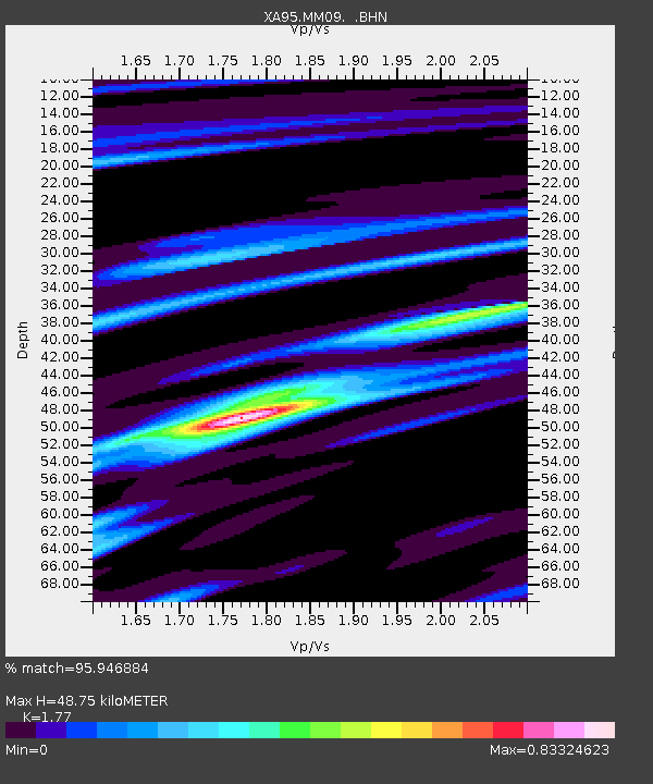
| Estimated Moho Depth: |
48.75 km |
| Estimated Crust Vp/Vs: |
1.77 |
| Assumed Crust Vp: |
6.483 km/s |
| Estimated Crust Vs: |
3.662 km/s |
| Estimated Crust Poisson's Ratio: |
0.27 |
|
| Radial Match: |
95.946884 % |
| Radial Bump: |
358 |
| Transverse Match: |
73.09444 % |
| Transverse Bump: |
400 |
| SOD ConfigId: |
6273 |
| Insert Time: |
2010-02-26 17:50:07.726 +0000 |
| GWidth: |
2.5 |
| Max Bumps: |
400 |
| Tol: |
0.001 |
|
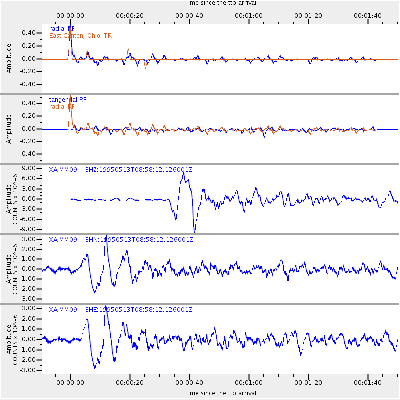
Signal To Noise
| Channel | StoN | STA | LTA |
| XA:MM09: :BHN:19950513T08:58:12.126001Z | 2.3118646 | 4.6402545E-7 | 2.0071481E-7 |
| XA:MM09: :BHE:19950513T08:58:12.126001Z | 2.8291674 | 4.348875E-7 | 1.5371573E-7 |
| XA:MM09: :BHZ:19950513T08:58:12.126001Z | 6.492056 | 1.341315E-6 | 2.0660868E-7 |
| Arrivals |
| Ps | 6.0 SECOND |
| PpPs | 20 SECOND |
| PsPs/PpSs | 26 SECOND |


