You are here: Home > Network List > TA - USArray Transportable Network (new EarthScope stations) Stations List
> Station 226B Tecolote Peak, Malaga, NM, USA > Earthquake Result Viewer
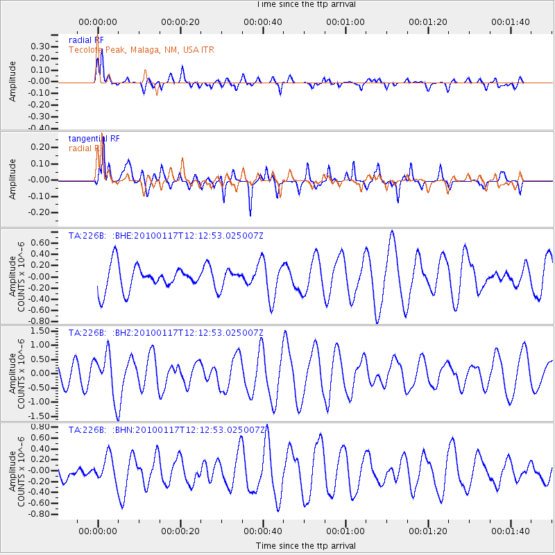
226B Tecolote Peak, Malaga, NM, USA - Earthquake Result Viewer
*The percent match for this event was below the threshold and hence no stack was calculated.
| Earthquake location: |
Drake Passage |
| Earthquake latitude/longitude: |
-57.7/-65.9 |
| Earthquake time(UTC): |
2010/01/17 (017) 12:00:01 GMT |
| Earthquake Depth: |
5.0 km |
| Earthquake Magnitude: |
6.0 MB, 6.0 MS, 6.3 MW, 6.3 MW |
| Earthquake Catalog/Contributor: |
WHDF/NEIC |
|
| Network: |
TA USArray Transportable Network (new EarthScope stations) |
| Station: |
226B Tecolote Peak, Malaga, NM, USA |
| Lat/Lon: |
32.08 N/104.17 W |
| Elevation: |
981 m |
|
| Distance: |
95.0 deg |
| Az: |
328.128 deg |
| Baz: |
160.471 deg |
| Ray Param: |
$rayparam |
*The percent match for this event was below the threshold and hence was not used in the summary stack. |
|
| Radial Match: |
73.460754 % |
| Radial Bump: |
400 |
| Transverse Match: |
81.18052 % |
| Transverse Bump: |
326 |
| SOD ConfigId: |
296938 |
| Insert Time: |
2010-04-06 20:56:41.354 +0000 |
| GWidth: |
2.5 |
| Max Bumps: |
400 |
| Tol: |
0.001 |
|
Signal To Noise
| Channel | StoN | STA | LTA |
| TA:226B: :BHZ:20100117T12:12:53.025007Z | 2.3598456 | 7.869681E-7 | 3.3348286E-7 |
| TA:226B: :BHN:20100117T12:12:53.025007Z | 1.6227393 | 2.3742585E-7 | 1.4631176E-7 |
| TA:226B: :BHE:20100117T12:12:53.025007Z | 0.71367836 | 1.5733232E-7 | 2.204527E-7 |
| Arrivals |
| Ps | |
| PpPs | |
| PsPs/PpSs | |


