You are here: Home > Network List > XA95 - Missouri to Massachusetts Transect Stations List
> Station MM09 East Canton, Ohio > Earthquake Result Viewer
MM09 East Canton, Ohio - Earthquake Result Viewer
| Earthquake location: |
Near Coast Of Peru |
| Earthquake latitude/longitude: |
-10.5/-78.7 |
| Earthquake time(UTC): |
1995/09/23 (266) 22:31:58 GMT |
| Earthquake Depth: |
73 km |
| Earthquake Magnitude: |
5.9 MB, 6.5 UNKNOWN, 6.4 MW |
| Earthquake Catalog/Contributor: |
WHDF/NEIC |
|
| Network: |
XA Missouri to Massachusetts Transect |
| Station: |
MM09 East Canton, Ohio |
| Lat/Lon: |
40.79 N/81.21 W |
| Elevation: |
357 m |
|
| Distance: |
51.1 deg |
| Az: |
357.553 deg |
| Baz: |
176.83 deg |
| Ray Param: |
0.06741125 |
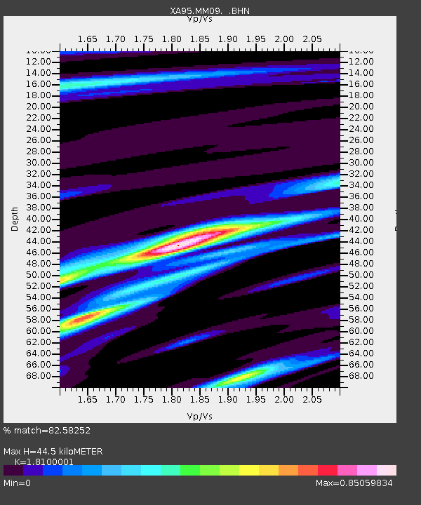
| Estimated Moho Depth: |
44.5 km |
| Estimated Crust Vp/Vs: |
1.81 |
| Assumed Crust Vp: |
6.483 km/s |
| Estimated Crust Vs: |
3.582 km/s |
| Estimated Crust Poisson's Ratio: |
0.28 |
|
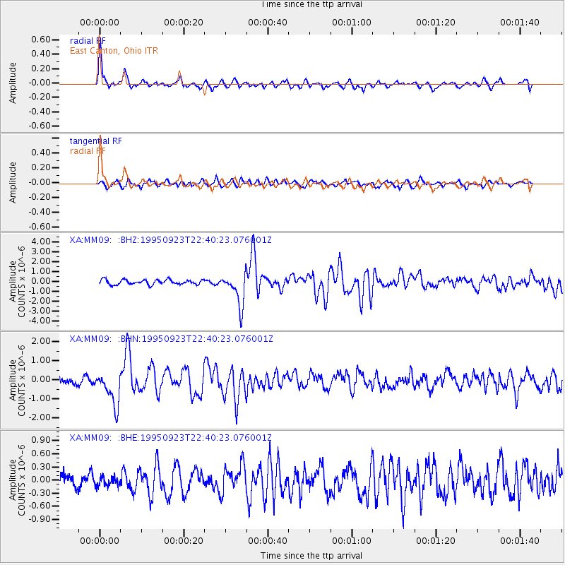
| Radial Match: |
82.58252 % |
| Radial Bump: |
398 |
| Transverse Match: |
72.37786 % |
| Transverse Bump: |
400 |
| SOD ConfigId: |
6273 |
| Insert Time: |
2010-02-26 17:50:11.001 +0000 |
| GWidth: |
2.5 |
| Max Bumps: |
400 |
| Tol: |
0.001 |
|
Signal To Noise
| Channel | StoN | STA | LTA |
| XA:MM09: :BHN:19950923T22:40:23.076001Z | 5.1471925 | 9.019444E-7 | 1.7523035E-7 |
| XA:MM09: :BHE:19950923T22:40:23.076001Z | 0.5987308 | 1.1334734E-7 | 1.893127E-7 |
| XA:MM09: :BHZ:19950923T22:40:23.076001Z | 7.07617 | 1.7109198E-6 | 2.4178615E-7 |
| Arrivals |
| Ps | 5.9 SECOND |
| PpPs | 18 SECOND |
| PsPs/PpSs | 24 SECOND |


