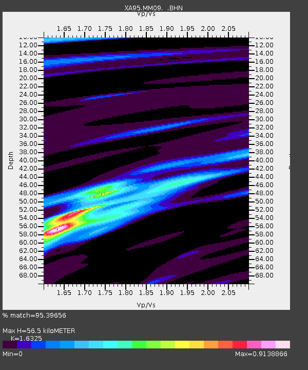
MM09 East Canton, Ohio - Earthquake Result Viewer
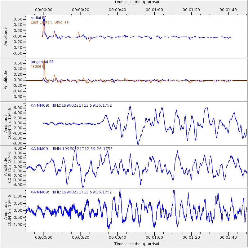
Earthquake location: Off Coast Of Northern Peru
Earthquake latitude/longitude: -9.6/-79.6
Earthquake time(UTC): 1996/02/21 (052) 12:51:04 GMT
Earthquake Depth: 33 km
Earthquake Magnitude: 5.8 MB, 6.6 MS, 7.5 UNKNOWN, 7.3 MW
Earthquake Catalog/Contributor: WHDF/NEIC
Network: XA Missouri to Massachusetts Transect
Station: MM09 East Canton, Ohio
Lat/Lon: 40.79 N/81.21 W
Elevation: 357 m
Distance: 50.2 deg
Az: 358.381 deg
Baz: 177.897 deg
Ray Param: 0.06816487
Estimated Moho Depth: 56.5 km
Estimated Crust Vp/Vs: 1.63
Assumed Crust Vp: 6.483 km/s
Estimated Crust Vs: 3.971 km/s
Estimated Crust Poisson's Ratio: 0.20
Radial Match: 95.39656 %
Radial Bump: 283
Transverse Match: 73.46538 %
Transverse Bump: 400
SOD ConfigId: 6273
Insert Time: 2010-02-26 17:50:12.140 +0000
GWidth: 2.5
Max Bumps: 400
Tol: 0.001

Signal To Noise

ChannelStoNSTALTA
XA:MM09: :BHN:19960221T12:59:26.175Z4.13963651.032513E-62.4942116E-7
XA:MM09: :BHE:19960221T12:59:26.175Z0.96907021.9748245E-72.0378549E-7
XA:MM09: :BHZ:19960221T12:59:26.175Z8.0007341.7751494E-62.2187331E-7
Arrivals
Ps5.9 SECOND
PpPs22 SECOND
PsPs/PpSs27 SECOND