You are here: Home > Network List > IU - Global Seismograph Network (GSN - IRIS/USGS) Stations List
> Station SLBS Sierra la Laguna Baja California Sur, Mexico > Earthquake Result Viewer
SLBS Sierra la Laguna Baja California Sur, Mexico - Earthquake Result Viewer
| Earthquake location: |
South Of Fiji Islands |
| Earthquake latitude/longitude: |
-26.0/178.4 |
| Earthquake time(UTC): |
2022/11/09 (313) 09:38:42 GMT |
| Earthquake Depth: |
629 km |
| Earthquake Magnitude: |
6.8 mww |
| Earthquake Catalog/Contributor: |
NEIC PDE/us |
|
| Network: |
IU Global Seismograph Network (GSN - IRIS/USGS) |
| Station: |
SLBS Sierra la Laguna Baja California Sur, Mexico |
| Lat/Lon: |
23.69 N/109.94 W |
| Elevation: |
825 m |
|
| Distance: |
85.1 deg |
| Az: |
60.872 deg |
| Baz: |
239.065 deg |
| Ray Param: |
0.04313854 |
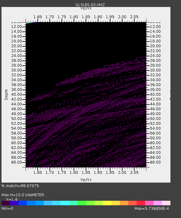
| Estimated Moho Depth: |
10.0 km |
| Estimated Crust Vp/Vs: |
1.60 |
| Assumed Crust Vp: |
6.183 km/s |
| Estimated Crust Vs: |
3.864 km/s |
| Estimated Crust Poisson's Ratio: |
0.18 |
|
| Radial Match: |
99.87875 % |
| Radial Bump: |
4 |
| Transverse Match: |
99.87426 % |
| Transverse Bump: |
2 |
| SOD ConfigId: |
29734672 |
| Insert Time: |
2022-11-23 09:59:31.885 +0000 |
| GWidth: |
2.5 |
| Max Bumps: |
400 |
| Tol: |
0.001 |
|
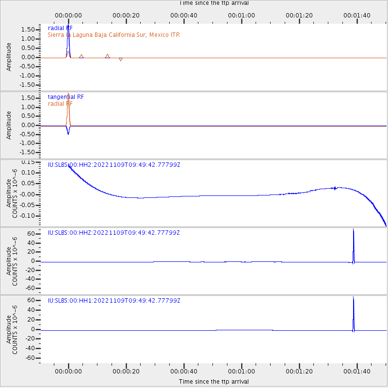
Signal To Noise
| Channel | StoN | STA | LTA |
| IU:SLBS:00:HHZ:20221109T09:49:42.77799Z | 1.0001489 | 4.5144635E-8 | 4.5137917E-8 |
| IU:SLBS:00:HH1:20221109T09:49:42.77799Z | 0.8983409 | 3.9565784E-8 | 4.4043173E-8 |
| IU:SLBS:00:HH2:20221109T09:49:42.77799Z | 0.89742625 | 3.9477783E-8 | 4.3990003E-8 |
| Arrivals |
| Ps | 1.0 SECOND |
| PpPs | 4.1 SECOND |
| PsPs/PpSs | 5.1 SECOND |


