You are here: Home > Network List > CB - China National Seismic Network Stations List
> Station SNY Shenyang,Liaoning Province > Earthquake Result Viewer
SNY Shenyang,Liaoning Province - Earthquake Result Viewer
| Earthquake location: |
Minahassa Peninsula, Sulawesi |
| Earthquake latitude/longitude: |
0.4/122.0 |
| Earthquake time(UTC): |
2017/07/15 (196) 12:12:21 GMT |
| Earthquake Depth: |
114 km |
| Earthquake Magnitude: |
5.9 Mww |
| Earthquake Catalog/Contributor: |
NEIC PDE/us |
|
| Network: |
CB China National Seismic Network |
| Station: |
SNY Shenyang,Liaoning Province |
| Lat/Lon: |
41.83 N/123.58 E |
| Elevation: |
54 m |
|
| Distance: |
41.3 deg |
| Az: |
1.755 deg |
| Baz: |
182.348 deg |
| Ray Param: |
0.07348592 |
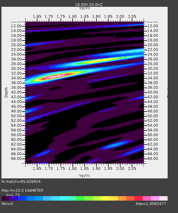
| Estimated Moho Depth: |
33.0 km |
| Estimated Crust Vp/Vs: |
1.73 |
| Assumed Crust Vp: |
6.464 km/s |
| Estimated Crust Vs: |
3.736 km/s |
| Estimated Crust Poisson's Ratio: |
0.25 |
|
| Radial Match: |
95.826904 % |
| Radial Bump: |
221 |
| Transverse Match: |
86.56853 % |
| Transverse Bump: |
400 |
| SOD ConfigId: |
2973751 |
| Insert Time: |
2018-10-08 19:30:57.334 +0000 |
| GWidth: |
2.5 |
| Max Bumps: |
400 |
| Tol: |
0.001 |
|

Signal To Noise
| Channel | StoN | STA | LTA |
| CB:SNY:00:BHZ:20170715T12:19:25.049994Z | 3.5313554 | 1.8029542E-7 | 5.1055586E-8 |
| CB:SNY:00:BHN:20170715T12:19:25.049994Z | 1.726039 | 1.1406157E-7 | 6.608285E-8 |
| CB:SNY:00:BHE:20170715T12:19:25.049994Z | 1.0480841 | 5.1227463E-8 | 4.887724E-8 |
| Arrivals |
| Ps | 4.0 SECOND |
| PpPs | 13 SECOND |
| PsPs/PpSs | 17 SECOND |


