You are here: Home > Network List > TA - USArray Transportable Network (new EarthScope stations) Stations List
> Station 633A Saathoff Ranch, Hondo, TX, USA > Earthquake Result Viewer
633A Saathoff Ranch, Hondo, TX, USA - Earthquake Result Viewer
| Earthquake location: |
Drake Passage |
| Earthquake latitude/longitude: |
-57.7/-65.9 |
| Earthquake time(UTC): |
2010/01/17 (017) 12:00:01 GMT |
| Earthquake Depth: |
5.0 km |
| Earthquake Magnitude: |
6.0 MB, 6.0 MS, 6.3 MW, 6.3 MW |
| Earthquake Catalog/Contributor: |
WHDF/NEIC |
|
| Network: |
TA USArray Transportable Network (new EarthScope stations) |
| Station: |
633A Saathoff Ranch, Hondo, TX, USA |
| Lat/Lon: |
29.46 N/99.18 W |
| Elevation: |
320 m |
|
| Distance: |
91.2 deg |
| Az: |
331.387 deg |
| Baz: |
162.835 deg |
| Ray Param: |
0.041620176 |
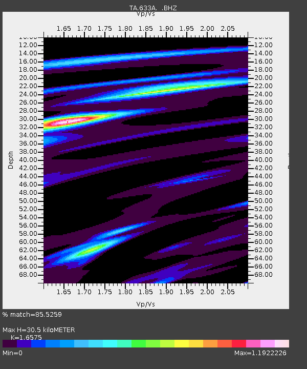
| Estimated Moho Depth: |
30.5 km |
| Estimated Crust Vp/Vs: |
1.66 |
| Assumed Crust Vp: |
6.347 km/s |
| Estimated Crust Vs: |
3.829 km/s |
| Estimated Crust Poisson's Ratio: |
0.21 |
|
| Radial Match: |
85.5259 % |
| Radial Bump: |
375 |
| Transverse Match: |
58.574924 % |
| Transverse Bump: |
400 |
| SOD ConfigId: |
296938 |
| Insert Time: |
2010-04-06 21:01:20.512 +0000 |
| GWidth: |
2.5 |
| Max Bumps: |
400 |
| Tol: |
0.001 |
|
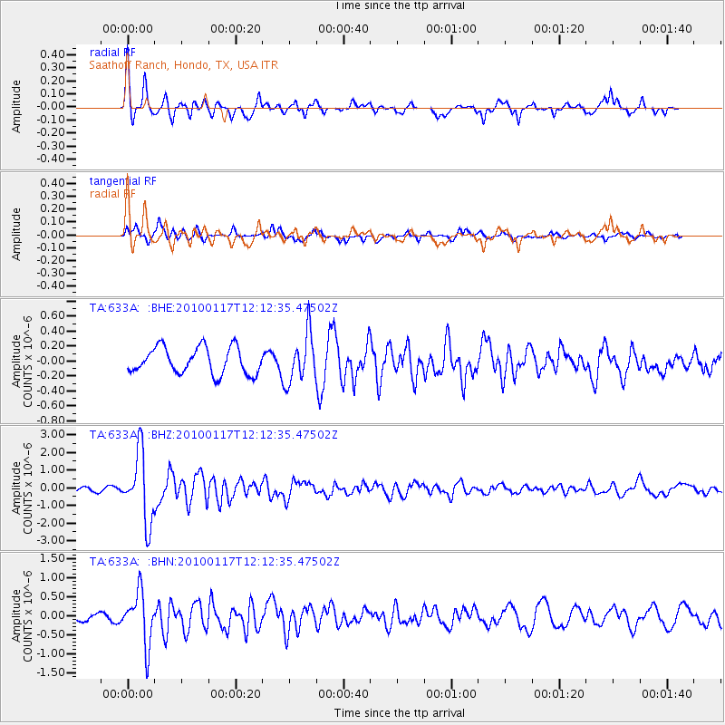
Signal To Noise
| Channel | StoN | STA | LTA |
| TA:633A: :BHZ:20100117T12:12:35.47502Z | 13.096032 | 1.9757297E-6 | 1.5086475E-7 |
| TA:633A: :BHN:20100117T12:12:35.47502Z | 3.9834406 | 6.9718647E-7 | 1.7502117E-7 |
| TA:633A: :BHE:20100117T12:12:35.47502Z | 1.8566859 | 3.249075E-7 | 1.7499326E-7 |
| Arrivals |
| Ps | 3.2 SECOND |
| PpPs | 12 SECOND |
| PsPs/PpSs | 16 SECOND |


