You are here: Home > Network List > IU - Global Seismograph Network (GSN - IRIS/USGS) Stations List
> Station SLBS Sierra la Laguna Baja California Sur, Mexico > Earthquake Result Viewer
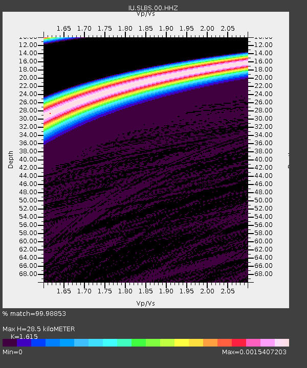
SLBS Sierra la Laguna Baja California Sur, Mexico - Earthquake Result Viewer
| Earthquake location: |
South Of Fiji Islands |
| Earthquake latitude/longitude: |
-25.6/178.3 |
| Earthquake time(UTC): |
2022/11/09 (313) 10:14:33 GMT |
| Earthquake Depth: |
624 km |
| Earthquake Magnitude: |
6.6 Mww |
| Earthquake Catalog/Contributor: |
NEIC PDE/us |
|
| Network: |
IU Global Seismograph Network (GSN - IRIS/USGS) |
| Station: |
SLBS Sierra la Laguna Baja California Sur, Mexico |
| Lat/Lon: |
23.69 N/109.94 W |
| Elevation: |
825 m |
|
| Distance: |
85.0 deg |
| Az: |
60.94 deg |
| Baz: |
239.428 deg |
| Ray Param: |
0.043238003 |
| Estimated Moho Depth: |
28.5 km |
| Estimated Crust Vp/Vs: |
1.62 |
| Assumed Crust Vp: |
6.183 km/s |
| Estimated Crust Vs: |
3.828 km/s |
| Estimated Crust Poisson's Ratio: |
0.19 |
|
| Radial Match: |
99.98853 % |
| Radial Bump: |
3 |
| Transverse Match: |
99.97259 % |
| Transverse Bump: |
4 |
| SOD ConfigId: |
29749952 |
| Insert Time: |
2022-11-23 10:37:00.776 +0000 |
| GWidth: |
2.5 |
| Max Bumps: |
400 |
| Tol: |
0.001 |
|

Signal To Noise
| Channel | StoN | STA | LTA |
| IU:SLBS:00:HHZ:20221109T10:25:33.428024Z | 8.005219 | 4.4109547E-6 | 5.5100986E-7 |
| IU:SLBS:00:HH1:20221109T10:25:33.428024Z | 8.1236105 | 4.2507145E-6 | 5.2325436E-7 |
| IU:SLBS:00:HH2:20221109T10:25:33.428024Z | 8.123973 | 4.2554443E-6 | 5.2381324E-7 |
| Arrivals |
| Ps | 2.9 SECOND |
| PpPs | 12 SECOND |
| PsPs/PpSs | 15 SECOND |


