You are here: Home > Network List > US - United States National Seismic Network Stations List
> Station HAWA Hanford, Washington, USA > Earthquake Result Viewer
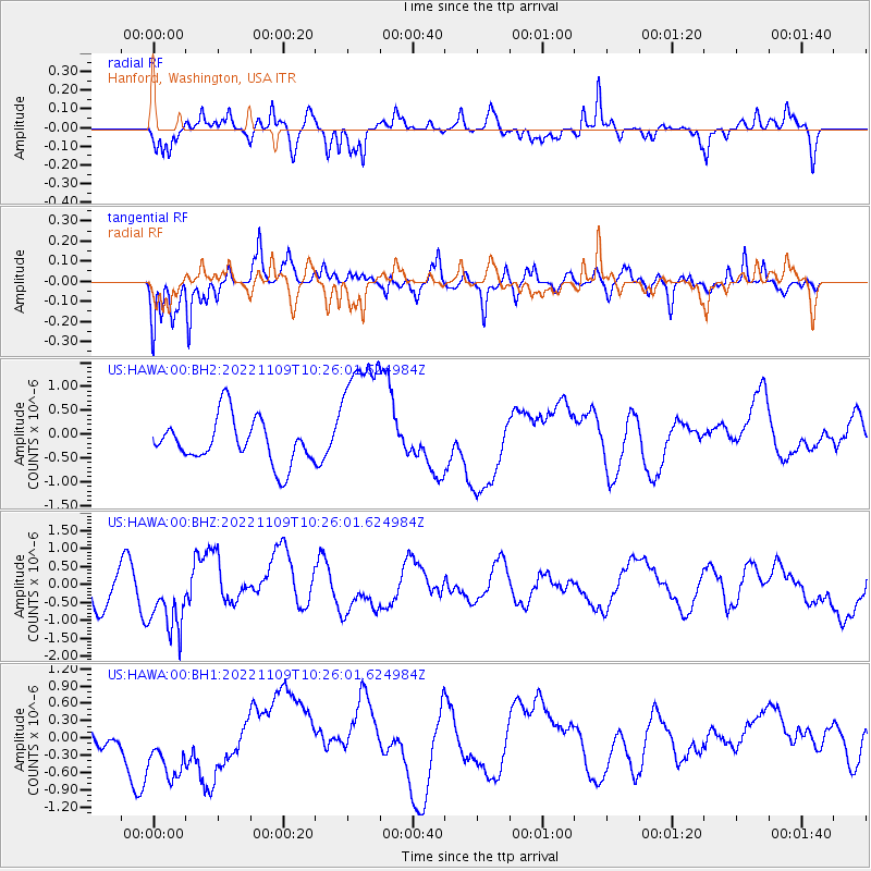
HAWA Hanford, Washington, USA - Earthquake Result Viewer
*The percent match for this event was below the threshold and hence no stack was calculated.
| Earthquake location: |
South Of Fiji Islands |
| Earthquake latitude/longitude: |
-25.6/178.3 |
| Earthquake time(UTC): |
2022/11/09 (313) 10:14:33 GMT |
| Earthquake Depth: |
624 km |
| Earthquake Magnitude: |
6.6 Mww |
| Earthquake Catalog/Contributor: |
NEIC PDE/us |
|
| Network: |
US United States National Seismic Network |
| Station: |
HAWA Hanford, Washington, USA |
| Lat/Lon: |
46.39 N/119.53 W |
| Elevation: |
364 m |
|
| Distance: |
91.1 deg |
| Az: |
37.756 deg |
| Baz: |
233.019 deg |
| Ray Param: |
$rayparam |
*The percent match for this event was below the threshold and hence was not used in the summary stack. |
|
| Radial Match: |
68.286125 % |
| Radial Bump: |
369 |
| Transverse Match: |
53.359104 % |
| Transverse Bump: |
365 |
| SOD ConfigId: |
29749952 |
| Insert Time: |
2022-11-23 10:43:06.403 +0000 |
| GWidth: |
2.5 |
| Max Bumps: |
400 |
| Tol: |
0.001 |
|
Signal To Noise
| Channel | StoN | STA | LTA |
| US:HAWA:00:BHZ:20221109T10:26:01.624984Z | 2.005137 | 9.440366E-7 | 4.7080903E-7 |
| US:HAWA:00:BH1:20221109T10:26:01.624984Z | 1.8306772 | 6.553239E-7 | 3.5796805E-7 |
| US:HAWA:00:BH2:20221109T10:26:01.624984Z | 3.0253608 | 1.4078377E-6 | 4.6534538E-7 |
| Arrivals |
| Ps | |
| PpPs | |
| PsPs/PpSs | |


