You are here: Home > Network List > AK - Alaska Regional Network Stations List
> Station B22K Teshekpuk Lake, AK, USA > Earthquake Result Viewer
B22K Teshekpuk Lake, AK, USA - Earthquake Result Viewer
| Earthquake location: |
Tonga Islands Region |
| Earthquake latitude/longitude: |
-19.3/-172.1 |
| Earthquake time(UTC): |
2022/11/11 (315) 10:48:45 GMT |
| Earthquake Depth: |
25 km |
| Earthquake Magnitude: |
7.3 Mww |
| Earthquake Catalog/Contributor: |
NEIC PDE/us |
|
| Network: |
AK Alaska Regional Network |
| Station: |
B22K Teshekpuk Lake, AK, USA |
| Lat/Lon: |
70.34 N/153.42 W |
| Elevation: |
50 m |
|
| Distance: |
90.4 deg |
| Az: |
6.223 deg |
| Baz: |
197.607 deg |
| Ray Param: |
0.041705333 |
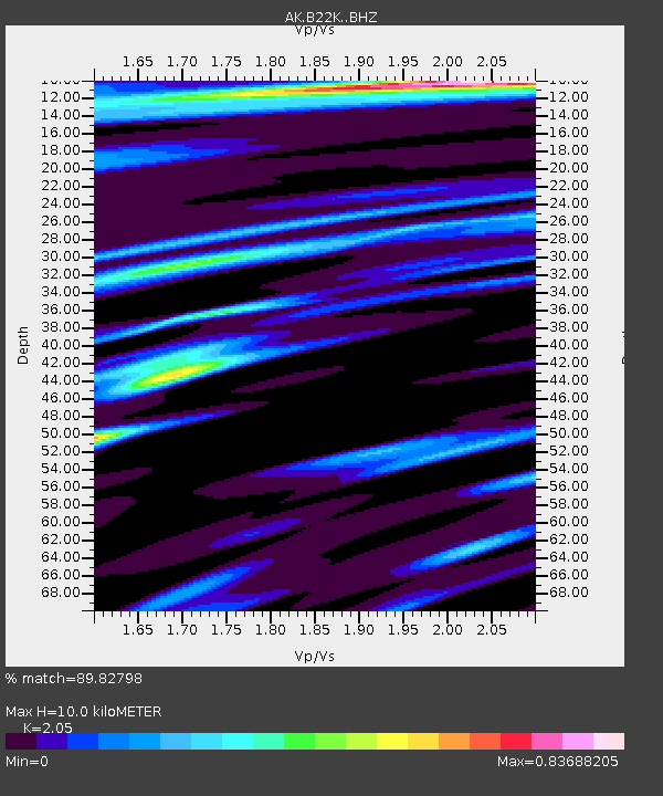
| Estimated Moho Depth: |
10.0 km |
| Estimated Crust Vp/Vs: |
2.05 |
| Assumed Crust Vp: |
5.738 km/s |
| Estimated Crust Vs: |
2.799 km/s |
| Estimated Crust Poisson's Ratio: |
0.34 |
|
| Radial Match: |
89.82798 % |
| Radial Bump: |
400 |
| Transverse Match: |
71.37768 % |
| Transverse Bump: |
400 |
| SOD ConfigId: |
29756493 |
| Insert Time: |
2022-11-25 10:52:00.719 +0000 |
| GWidth: |
2.5 |
| Max Bumps: |
400 |
| Tol: |
0.001 |
|

Signal To Noise
| Channel | StoN | STA | LTA |
| AK:B22K: :BHZ:20221111T11:01:12.680003Z | 9.636061 | 6.142208E-6 | 6.3741896E-7 |
| AK:B22K: :BHN:20221111T11:01:12.680003Z | 3.4656768 | 1.8035198E-6 | 5.2039474E-7 |
| AK:B22K: :BHE:20221111T11:01:12.680003Z | 1.5776473 | 1.0167702E-6 | 6.444851E-7 |
| Arrivals |
| Ps | 1.9 SECOND |
| PpPs | 5.2 SECOND |
| PsPs/PpSs | 7.1 SECOND |


