You are here: Home > Network List > AK - Alaska Regional Network Stations List
> Station BGLC Bering Glacier BLM Camp, AK, USA > Earthquake Result Viewer
BGLC Bering Glacier BLM Camp, AK, USA - Earthquake Result Viewer
| Earthquake location: |
Tonga Islands Region |
| Earthquake latitude/longitude: |
-19.3/-172.1 |
| Earthquake time(UTC): |
2022/11/11 (315) 10:48:45 GMT |
| Earthquake Depth: |
25 km |
| Earthquake Magnitude: |
7.3 Mww |
| Earthquake Catalog/Contributor: |
NEIC PDE/us |
|
| Network: |
AK Alaska Regional Network |
| Station: |
BGLC Bering Glacier BLM Camp, AK, USA |
| Lat/Lon: |
60.12 N/143.28 W |
| Elevation: |
10 m |
|
| Distance: |
82.6 deg |
| Az: |
14.087 deg |
| Baz: |
207.327 deg |
| Ray Param: |
0.04678564 |
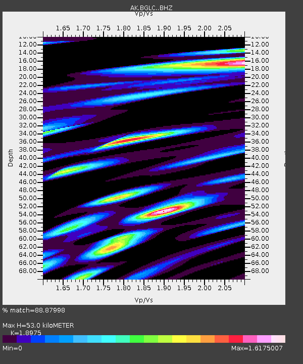
| Estimated Moho Depth: |
53.0 km |
| Estimated Crust Vp/Vs: |
1.90 |
| Assumed Crust Vp: |
6.566 km/s |
| Estimated Crust Vs: |
3.46 km/s |
| Estimated Crust Poisson's Ratio: |
0.31 |
|
| Radial Match: |
88.87998 % |
| Radial Bump: |
400 |
| Transverse Match: |
69.84283 % |
| Transverse Bump: |
400 |
| SOD ConfigId: |
29756493 |
| Insert Time: |
2022-11-25 10:52:16.151 +0000 |
| GWidth: |
2.5 |
| Max Bumps: |
400 |
| Tol: |
0.001 |
|

Signal To Noise
| Channel | StoN | STA | LTA |
| AK:BGLC: :BHZ:20221111T11:00:34.427989Z | 4.8638115 | 1.1061815E-5 | 2.27431E-6 |
| AK:BGLC: :BHN:20221111T11:00:34.427989Z | 1.7745003 | 7.2543107E-6 | 4.088087E-6 |
| AK:BGLC: :BHE:20221111T11:00:34.427989Z | 0.6183264 | 3.8454677E-6 | 6.219155E-6 |
| Arrivals |
| Ps | 7.4 SECOND |
| PpPs | 23 SECOND |
| PsPs/PpSs | 30 SECOND |


