You are here: Home > Network List > AU - Australian Seismological Centre Stations List
> Station KLGHS Kalgoorlie Hannans Street, WA GSWA network > Earthquake Result Viewer
KLGHS Kalgoorlie Hannans Street, WA GSWA network - Earthquake Result Viewer
| Earthquake location: |
Tonga Islands Region |
| Earthquake latitude/longitude: |
-19.3/-172.1 |
| Earthquake time(UTC): |
2022/11/11 (315) 10:48:45 GMT |
| Earthquake Depth: |
25 km |
| Earthquake Magnitude: |
7.3 Mww |
| Earthquake Catalog/Contributor: |
NEIC PDE/us |
|
| Network: |
AU Australian Seismological Centre |
| Station: |
KLGHS Kalgoorlie Hannans Street, WA GSWA network |
| Lat/Lon: |
30.75 S/121.47 E |
| Elevation: |
386 m |
|
| Distance: |
60.5 deg |
| Az: |
245.046 deg |
| Baz: |
96.0 deg |
| Ray Param: |
0.06147032 |
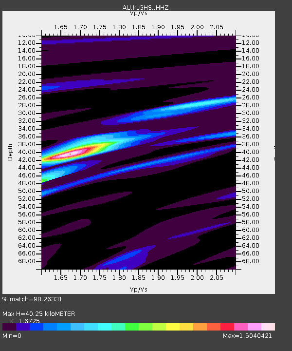
| Estimated Moho Depth: |
40.25 km |
| Estimated Crust Vp/Vs: |
1.67 |
| Assumed Crust Vp: |
6.459 km/s |
| Estimated Crust Vs: |
3.862 km/s |
| Estimated Crust Poisson's Ratio: |
0.22 |
|
| Radial Match: |
98.26331 % |
| Radial Bump: |
230 |
| Transverse Match: |
82.04141 % |
| Transverse Bump: |
400 |
| SOD ConfigId: |
29756493 |
| Insert Time: |
2022-11-25 10:57:45.412 +0000 |
| GWidth: |
2.5 |
| Max Bumps: |
400 |
| Tol: |
0.001 |
|

Signal To Noise
| Channel | StoN | STA | LTA |
| AU:KLGHS: :HHZ:20221111T10:58:21.950022Z | 5.9106174 | 4.6762007E-6 | 7.911526E-7 |
| AU:KLGHS: :HHN:20221111T10:58:21.950022Z | 0.73415256 | 7.266117E-7 | 9.897284E-7 |
| AU:KLGHS: :HHE:20221111T10:58:21.950022Z | 4.109996 | 2.4028518E-6 | 5.846361E-7 |
| Arrivals |
| Ps | 4.4 SECOND |
| PpPs | 16 SECOND |
| PsPs/PpSs | 20 SECOND |


