You are here: Home > Network List > AV - Alaska Volcano Observatory Stations List
> Station GALA Lava Point, Gareloi Volcano, Alaska > Earthquake Result Viewer
GALA Lava Point, Gareloi Volcano, Alaska - Earthquake Result Viewer
| Earthquake location: |
Tonga Islands Region |
| Earthquake latitude/longitude: |
-19.3/-172.1 |
| Earthquake time(UTC): |
2022/11/11 (315) 10:48:45 GMT |
| Earthquake Depth: |
25 km |
| Earthquake Magnitude: |
7.3 Mww |
| Earthquake Catalog/Contributor: |
NEIC PDE/us |
|
| Network: |
AV Alaska Volcano Observatory |
| Station: |
GALA Lava Point, Gareloi Volcano, Alaska |
| Lat/Lon: |
51.76 N/178.77 W |
| Elevation: |
315 m |
|
| Distance: |
71.0 deg |
| Az: |
355.619 deg |
| Baz: |
173.335 deg |
| Ray Param: |
0.05457348 |
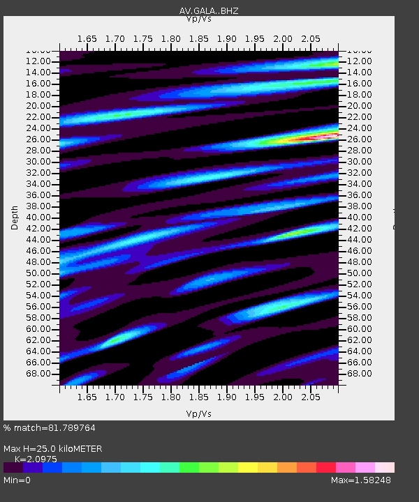
| Estimated Moho Depth: |
25.0 km |
| Estimated Crust Vp/Vs: |
2.10 |
| Assumed Crust Vp: |
6.048 km/s |
| Estimated Crust Vs: |
2.883 km/s |
| Estimated Crust Poisson's Ratio: |
0.35 |
|
| Radial Match: |
81.789764 % |
| Radial Bump: |
400 |
| Transverse Match: |
83.508194 % |
| Transverse Bump: |
400 |
| SOD ConfigId: |
29756493 |
| Insert Time: |
2022-11-25 10:58:16.964 +0000 |
| GWidth: |
2.5 |
| Max Bumps: |
400 |
| Tol: |
0.001 |
|

Signal To Noise
| Channel | StoN | STA | LTA |
| AV:GALA: :BHZ:20221111T10:59:29.55897Z | 4.2177963 | 9.34309E-6 | 2.2151592E-6 |
| AV:GALA: :BHN:20221111T10:59:29.55897Z | 1.0190076 | 4.6858418E-6 | 4.598437E-6 |
| AV:GALA: :BHE:20221111T10:59:29.55897Z | 0.9747631 | 3.6718716E-6 | 3.7669374E-6 |
| Arrivals |
| Ps | 4.7 SECOND |
| PpPs | 12 SECOND |
| PsPs/PpSs | 17 SECOND |


