You are here: Home > Network List > AV - Alaska Volcano Observatory Stations List
> Station MAPS Pakushin Southeast, Makushin Volcano, Alaska > Earthquake Result Viewer
MAPS Pakushin Southeast, Makushin Volcano, Alaska - Earthquake Result Viewer
| Earthquake location: |
Tonga Islands Region |
| Earthquake latitude/longitude: |
-19.3/-172.1 |
| Earthquake time(UTC): |
2022/11/11 (315) 10:48:45 GMT |
| Earthquake Depth: |
25 km |
| Earthquake Magnitude: |
7.3 Mww |
| Earthquake Catalog/Contributor: |
NEIC PDE/us |
|
| Network: |
AV Alaska Volcano Observatory |
| Station: |
MAPS Pakushin Southeast, Makushin Volcano, Alaska |
| Lat/Lon: |
53.81 N/166.94 W |
| Elevation: |
333 m |
|
| Distance: |
73.0 deg |
| Az: |
3.198 deg |
| Baz: |
185.096 deg |
| Ray Param: |
0.053297706 |
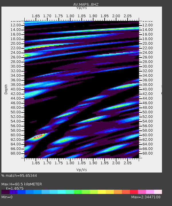
| Estimated Moho Depth: |
60.5 km |
| Estimated Crust Vp/Vs: |
1.66 |
| Assumed Crust Vp: |
3.943 km/s |
| Estimated Crust Vs: |
2.379 km/s |
| Estimated Crust Poisson's Ratio: |
0.21 |
|
| Radial Match: |
95.65344 % |
| Radial Bump: |
400 |
| Transverse Match: |
79.94638 % |
| Transverse Bump: |
400 |
| SOD ConfigId: |
29756493 |
| Insert Time: |
2022-11-25 10:58:40.165 +0000 |
| GWidth: |
2.5 |
| Max Bumps: |
400 |
| Tol: |
0.001 |
|
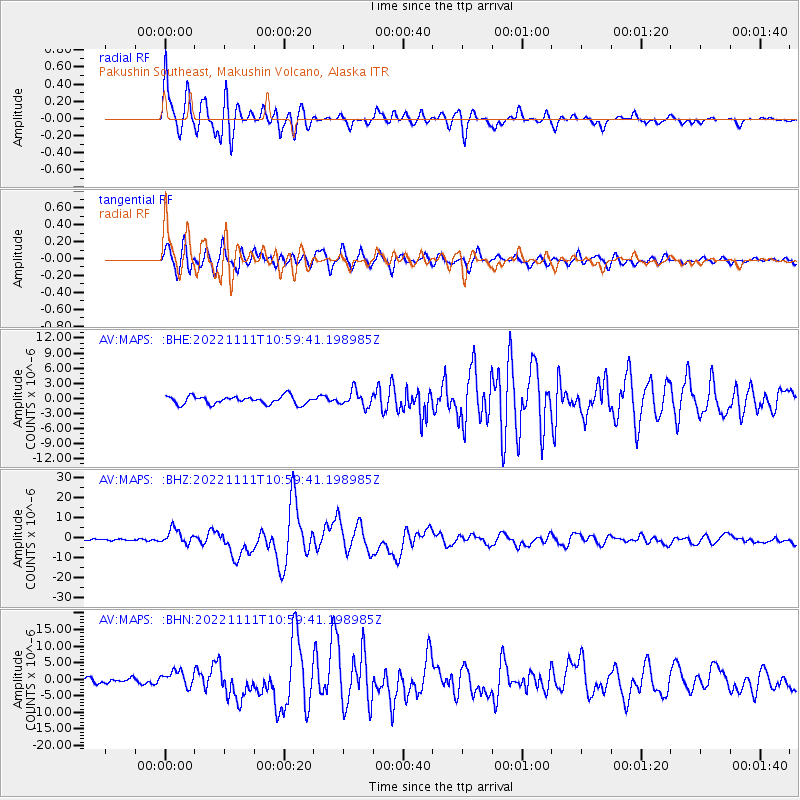
Signal To Noise
| Channel | StoN | STA | LTA |
| AV:MAPS: :BHZ:20221111T10:59:41.198985Z | 8.543526 | 3.7893226E-6 | 4.4353146E-7 |
| AV:MAPS: :BHN:20221111T10:59:41.198985Z | 3.1805868 | 2.3335401E-6 | 7.336822E-7 |
| AV:MAPS: :BHE:20221111T10:59:41.198985Z | 1.9255289 | 1.535458E-6 | 7.974214E-7 |
| Arrivals |
| Ps | 10 SECOND |
| PpPs | 40 SECOND |
| PsPs/PpSs | 50 SECOND |


